Even Sheffield's Council Leader called the Green Belt plan unfair
Last time we looked at whether the Council has actually assessed the farmland it intends to build on. On the evidence, it hasn't.
This email turns from individual sites to a different question: not what is being built, but where. Has Sheffield Council justified the distribution of Green Belt release it has chosen across the city?
The pattern is stark. On the Council's evidence, around 79% of the additional Green Belt housing release - some 3,092 of 3,906 homes - falls into the Northeast, Chapeltown/High Green and Southeast sub-areas.
All of the additional Green Belt employment release - 67.35 hectares - goes to the same parts of the city.
Combined, about 95% of the new release sits in just three of the nine housing sub-areas of Sheffield.
That is not a balanced city-wide strategy. It is a concentration. The Council has not, on the evidence available, explained why this distribution is the right one for the city.
What the distribution actually looks like
The additional Green Belt housing release breaks down as shown below.
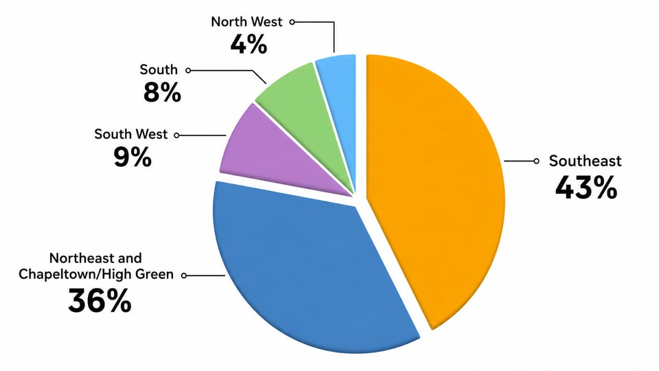
The Southeast sub-area, which contains S13, takes 43% on its own. Two sites in S13 - SES29 (Handsworth Hall Farm) and SES30 (Bramley Common), separated by less than 500 metres - account for that entire share: roughly 1,700 homes concentrated in a small part of the city.
On employment land, the pattern is starker: every hectare of additional Green Belt employment release is in the Northeast, Chapeltown/High Green or Southeast.
What the Council's own evidence admits
Concentrated development on this scale demands a cumulative assessment of the impacts.
The Council admits that it has not done one. Its Integrated Impact Assessment (IIA) Modifications Report Addendum (February 2026, p.120) says:
"Additional site allocations are likely to have cumulative effects on the IIA findings that need to be explored further."
That exploration has not been carried out. On traffic, for example, the Council has relied on generic, isolated assessments rather than specific, area-wide traffic modelling - as set out in the Aprica representation.
The IIA also confirms that the modified Plan performs less well than the submitted Plan on soil, landscape, biodiversity, and transport and accessibility - with the negative effects falling on the same sub-areas where release is concentrated.
The Council is asking the Inspectors to approve a concentrated Green Belt release of this scale without assessing its cumulative environmental, social and infrastructure harms.
National planning policy requires plans to be justified and effective on proportionate evidence (NPPF September 2023, paragraph 35). The Plan does not explain why a more even distribution was rejected. On spatial distribution, that makes the Plan unsound.
What the Inspectors asked for
In their February 2025 letter (para. 14), the Inspectors asked the Council to appraise smaller greenfield sites in the Green Belt as a reasonable alternative to large strategic allocations:
"We requested at the Stage 1 hearings that it should be expanded to include smaller site options on greenfield land in the Green Belt, on the grounds that this is a reasonable alternative strategy and should therefore be subject to appraisal."
What the Council delivered is the reverse. Although SES29 (870 homes) and SES30 (827 homes) sit below the 1,000-home "large site" threshold, the Council has combined them into a single "Strategic Location 1 (Handsworth)" of 1,697 homes to make the case for their release.
The smaller sites the Inspectors wanted have, in effect, been bundled into exactly the kind of large, concentrated releases they were supposed to be an alternative to.
What the then-Leader of the Council said on the record
Affected communities are not the only ones making this point. At Full Council on 3 September 2025, the then-Leader of the Council, Councillor Tom Hunt, said:
"I reiterate what I have said previously, that I do not think that the Plan represents a fair distribution. In the report that the Council voted upon back in mid-May, it said very clearly that 'we recognise that this is not an even distribution of sites in all areas of the city'. … I and my Labour Group colleagues pushed for more sites to be included from the south-west and west of the city. If the draft Plan is adopted in 2026, then it is my view that there should be a new Call for Sites … so that there is a fairer distribution of sites right across the city."
He repeated the point in response to a supplementary question at the same meeting, saying he would "like to see a fairer site distribution across the city" and that a new Call for Sites "should take place soon after" adoption.
Three things stand out. The Council's own political leadership accepted the distribution was not fair. The Council's report to members in May 2025 contained the same admission. And the suggested remedy was to look for new brownfield sites - but only after adoption.
"Fix it later" is not a remedy
A Local Plan has to be justified at the point of adoption. A fresh Call for Sites after adoption is not a fix for an unfair distribution. It is an admission that the present distribution is not the right one.
The right time to find alternative sites, and to secure a fairer distribution of any necessary Green Belt release, is before adoption - not after. If the Council itself thinks a new Call for Sites is needed to achieve a fair city-wide distribution, that is a reason to do the work now. It is not a reason to adopt an unfair distribution first.
Placing growth where the burden is heaviest
These proposals do not sit in a vacuum. When the Green Belt release is mapped against the 2025 Indices of Multiple Deprivation (IMD), the overwhelming majority of the new allocations fall in or next to areas that already experience some of the highest deprivation in the city - including Darnall, Woodhouse, Burngreave, Manor and Wybourn, Arbourthorne, Gleadless Valley, Firth Park, Shiregreen and Southey.
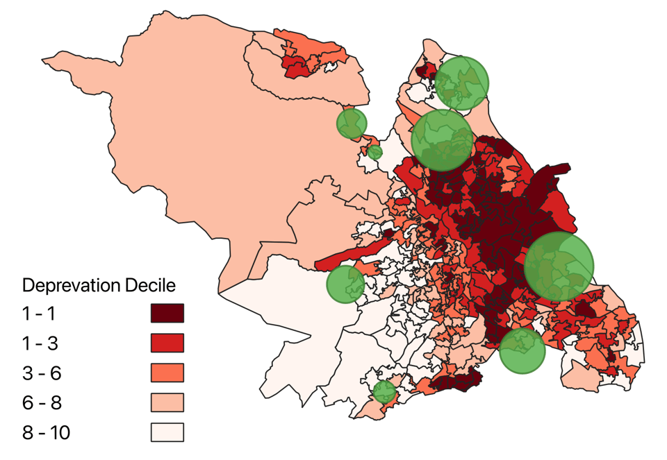
As Clive Betts MP told the Inspectors at the Stage 4 hearing on 15 October 2025: "It is fundamentally unfair and unjust."
Marie Tidball MP (Penistone and Stocksbridge) has made the same case on her area's share - 41% of new housing and 60% of new employment land in her constituency.
A fair plan would share the burden of growth across the city. These proposals concentrate growth on communities already facing the greatest disadvantage.
Where this leaves the Plan
The distribution of proposed Green Belt release is a deep flaw in Sheffield's spatial strategy.
And it is the fourth time in our series of emails that the same pattern has emerged: the Plan's evidence does not support the conclusions it asks councillors and the Inspectors to draw.
- On traffic, cumulative impacts were not modeled and the assumptions are optimistic.
- On site capacities, constraints have not been taking into account: the arithmetic does not add up.
- On farmland, the BMV assessment was never done.
- Now, on spatial distribution, the Council's previous Leader has said the result is not fair - and that a fresh Call for Sites is needed to put it right.
The Inspectors will now consider the evidence and issue their final report. After that, the Plan returns to Sheffield City Council for the adoption vote.
When it does, councillors will be asked to adopt a distribution that two of Sheffield's MPs, the Council's own report to members, and its previous Leader have already described as uneven or unfair.
Sheffield does need a Local Plan. But it needs to be fair and properly evidenced - not one that concentrates the burden on the same communities.
-The Save S13 Green Belt Campaign
What you can do right now
- Share this update: Forward this email to neighbours in S13, and to friends across Sheffield - this is a city-wide question, not just an S13 one.
- Read the spatial-distribution submission: Sheffield Green Belt Alliance representation to the Inspectors on MM10, MM91 and the spatial distribution of sites.
- Read what the MPs told the Inspectors: Clive Betts MP's submission and Marie Tidball MP's submission.
- Read how two sites became one: the representation showing how SES29 and SES30 were combined into a single 1,697-home "Strategic Location".