What our independent traffic review found
As promised last week, this is the first of a series of follow-up emails on representations submitted to the Main Modifications consultation.
We're starting with traffic - because it's the issue many residents experience every day, and because it's one of the clearest examples of the gap between what the Local Plan claims and what we know is already happening in our community.
The Save S13 Green Belt Campaign commissioned an independent review of the traffic impacts of the proposed S13 Green Belt sites: SES29 (Handsworth Hall Farm) and SES30 (Bramley Common).
The report was written by Ian Taylor I.Eng MICE of Aprica Ltd. He is an incorporated engineer with thirty-five years' experience in highways, road safety, transport planning and traffic management.
Its conclusion is simple: the evidence produced by Sheffield City Council does not show that the local road network can safely and sustainably take the extra traffic from both proposed sites.
The full 20-page Aprica report is on the website if you want to read the detail.
What is being proposed
- SES29 (Handsworth Hall Farm) is proposed for 870 homes and 20 hectares of employment land.
- SES30 (Bramley Common) is proposed for 827 homes, a secondary school, and a multi-faith burial ground.
The two sites lie about 1km apart by road. Together that means around 1,700 homes plus employment land, a school and a burial ground - all feeding traffic onto the same already-congested local network: Handsworth Road, Retford Road, Beaver Hill Road, Rotherham Road, Orgreave Lane, and the routes to and from the Parkway.
It's worth putting the scale in context. South East Sheffield was already set to take 3,064 homes under the existing Plan. SES29 and SES30 add 1,697 on top of that - a 55% increase in housing for this single sub-area, concentrated entirely in S13. This is on top of a further 2,000 homes still to be built across the road from SES29 at Waverley.
That is why Aprica looked not only at each site individually but at their cumulative effect.
What the report found
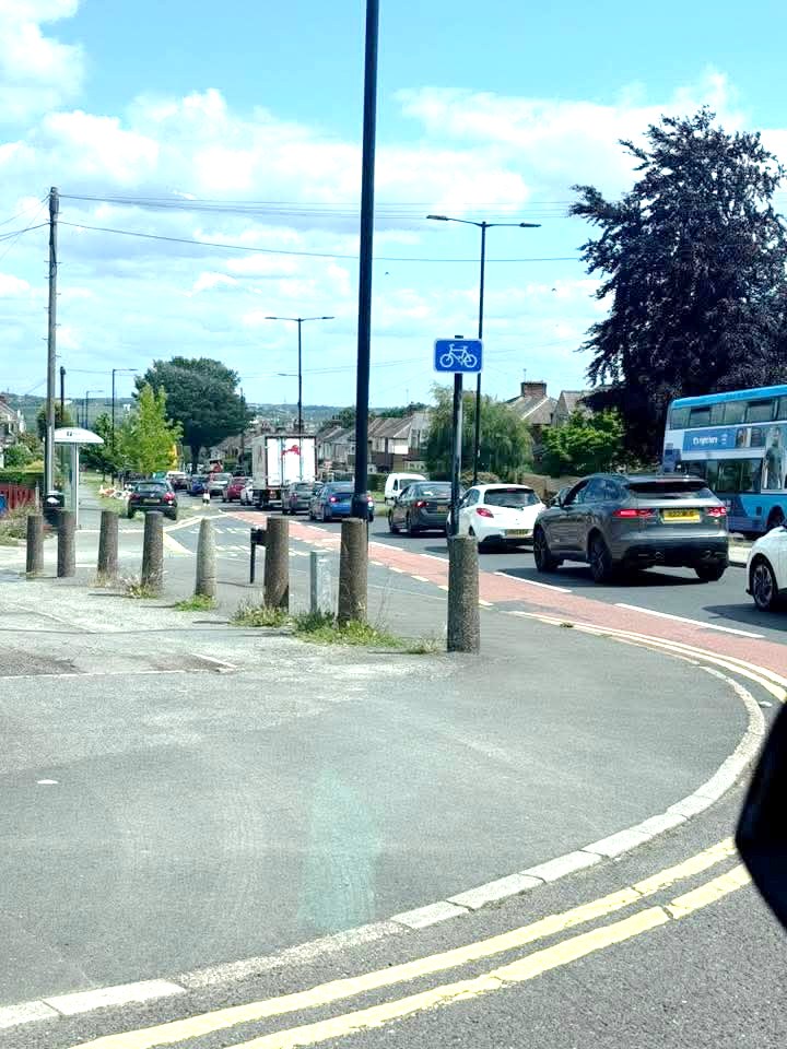
The local road network is already constrained. The queues, delays and rat-running aren't theoretical - they're visible every day around the Lidl/Rotherham Road junction, on Handsworth Road, on Beaver Hill Road, and along Orgreave Lane and Handsworth Grange Road.
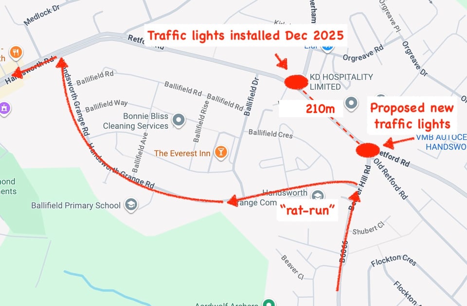
The Council's evidence accepts that the Retford Road/Beaver Hill Road junction will experience significant congestion, particularly in the PM peak. Their Strategic Road Network assessment shows that, even with the proposed “solution” of signalising all arms, that junction would be operating at 98% of capacity when the sites are developed.
But Aprica explains why those new lights will not solve the problem. They would sit roughly 210 metres from the lights installed last Christmas for the new Lidl on Rotherham Road. That is a short distance between two signalised junctions on already-busy roads - short enough for queues at one set of lights to back up through the other. The report warns of "blocking back": one junction effectively closes the other, causing gridlock.
And even with the mitigation in place, the Council's traffic model still predicts a PM peak queue of 52 car lengths. That isn't a problem solved. It's a problem documented, not answered.
There is a quieter contradiction also worth flagging. The Council's Integrated Impact Assessment acknowledges that:
… the local road network is known to be highly congested during peak hours, with development likely to add further pressure.
Then, in the same document, the IIA concludes that the location generates "moderate positive effects" in transport terms. The contradiction speaks for itself.
Why "people will walk, cycle or use public transport" is not enough
A major part of the Council's case depends on the idea that these sites can be made sustainable - by people walking, cycling or using public transport.
Aprica challenges that.
The sites sit at the “edge-of-settlement” and are separated from key destinations by busy B-roads. Beaver Hill Road is also steep - try walking to Woodhouse up Beaver Hill Road and Tithe Barn Lane.
Active Travel England (ATE) is the government's statutory inspectorate for sustainable travel. ATE’s recommended maximum gradient for walking and cycling routes is 1 in 20 (5%). Beaver Hill Road is typically 1 in 14 (around 7%), and in places 1 in 7 (around 14%) - above ATE's "critical" maximum of 8%. A painted line or a widened footway up steep hills does not create a safe or attractive active travel route.
The report notes that there has been no Active Travel Check on these sites, and that the proposals do not currently meet ATE's published national standards. ATE expects developments to enable at least 50% of short trips by sustainable modes by 2030. The report concludes there is no realistic prospect of that being achieved here.
Aprica also questions the assumption that rail can provide the solution. Woodhouse Station is at least 1.5km away, which is already at the limit of what many people will realistically walk to use rail day-to-day. The proposed Waverley station cannot currently be relied on either: it has no confirmed delivery timetable. As Network Rail says, the project “remains in the development phase”, with no formal milestones agreed. See our long-form article on the website for more detail.
But even if Waverley station were built, parts of SES30 would still be 1.25km to 1.7km away and require SES30 residents to drive to it along Beaver Hill Road and Rotherham Road.
Aprica’s analysis is that the Council has not shown a credible sustainable transport package for these sites. The gradients are too steep, the carriageways too narrow for LTN 1/20-compliant cycle infrastructure, and train stations are beyond reach. These sites will be car-dependent - not for lack of funding, but because no such package can be delivered here.
The underlying traffic numbers
The Council's traffic modelling depends on TRICS - the Trip Rate Information Computer System - an industry-standard database of trip-rate data drawn from comparable sites. Aprica raises a concern that's worth understanding.
Developers select which "comparable" sites are used to predict trips at a new development. If the chosen sites happen to be well-served by trams or major bus hubs, the predicted trip numbers come out lower - fewer cars, more sustainable journeys. ATE has already challenged the TRICS sample sites used in the Sheffield Plan assessments on exactly this basis.
There is a second issue. The planning convention is to model a typical busy day. The developer-friendly alternative is to model the average day, which makes the impact look smaller.
Aprica's concern is that the Council's modelling appears to have followed the developer convention rather than the planning convention, and the choice is poorly suited to these sites. School-run traffic on B-roads is not an average condition. Neither is a burial ground - for which the TRICS database may not contain meaningful comparators at all. The average day the Council has modelled may not exist for sites like these.
The report's point is not that TRICS is wrong. It's that the inputs and assumptions used here may be optimistic - and the real-world traffic numbers of these car-dominated sites would tend to exceed the model.
The school-run
SES30 also includes land safeguarded for a secondary school.
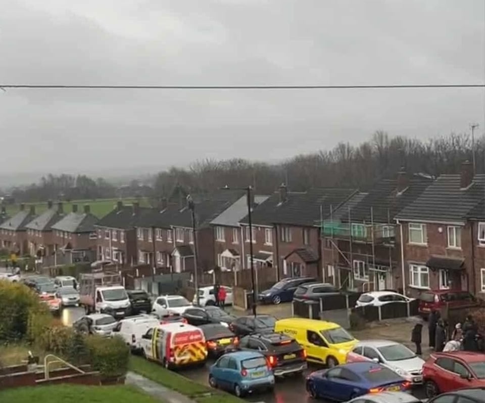
That may sound like useful community infrastructure, but from a traffic perspective it adds more peak-time pressure. Local roads already suffer school-run congestion, unsafe parking and blocked access around existing schools - reports describe parking on zig-zags, pavements, verges and private driveways around Handsworth Grange Academy and Ballifield Primary.
Adding another school to the same network doesn't relieve that existing problem. It compounds it.
The wider problem: this isn't just about two junctions
Aprica also looked beyond the immediate site entrances. The A630 Sheffield Parkway is less than 2km away. Traffic already moves between Handsworth, Woodhouse, Waverley, the Parkway, the Advanced Manufacturing Park, Dore House Industrial Estate, and local schools, shops and services. Handsworth Grange Road is a well-established rat-run between Beaver Hill Road/Handsworth Road and the Parkway.
Waverley sits directly across the road from SES29. Around 1,800 homes are already built there, with an overall capacity of around 4,000. The Waverley Link Road - proposed in 2010 to mitigate its traffic impact - was never built. And because Waverley sits in Rotherham rather than Sheffield, it has been treated as a separate problem in the Council's assessments. Administrative boundaries do not insulate residents from cumulative impact: traffic crosses council borders, as the Council's planners cannot have failed to notice.
The Council's Integrated Impact Assessment Addendum (paragraph 5.6.2) acknowledges that growth across the Handsworth Green Belt sites:
is likely to increase private vehicle and HGV movements … placing additional pressures on an already congested local highway network.
The Council has identified the problem in its own evidence. What it has not done is publish a single cumulative assessment that tests the combined effect of all this growth - SES29, SES30, the existing SES19-SES28 commitments, and the cross-boundary growth at Waverley - on the same map.
Road safety
For the latest verified five-year period (2020 to 2024), CrashMap records a high number of injury collisions in the area - particularly on Handsworth Road and Retford Road - including serious injuries and a fatality.
The Department for Transport estimates that for every reported injury collision there are roughly five unreported injury collisions and twenty damage-only collisions.
Aprica's position is that adding more traffic and more crossings to a network with this record raises road safety as a planning issue in its own right.
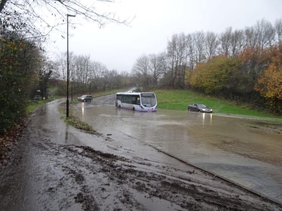
Aprica also identifies existing physical constraints on the network, including flooding close to the proposed SES30 access on Beaver Hill Road.
What Aprica says is needed
Aprica does not simply say "the traffic is bad". It sets out what the Council would need to demonstrate before these sites could safely be taken forward.
At a minimum, they call for:
- Robust trip-generation testing, using appropriate TRICS sample sites plus sensitivity tests for congested, car-dominant corridors.
- A full area-wide dynamic simulation covering both sites, the closely spaced signals, school peaks, and other committed development from Waverley and elsewhere in the area.
- A fully funded, deliverable sustainable transport package meeting Active Travel England expectations and LTN 1/20 standards, secured early rather than left as aspiration.
- Enforceable "Grampian conditions", so that necessary highway, safety and active travel measures are delivered before development begins, not after.
The report's conclusion is clear. If that evidence and those measures cannot be secured, SES29 and SES30 should be removed from the Sheffield Plan.
Why this matters now
The independent report has been submitted as part of the Save S13 response to the Main Modifications consultation.
The Inspectors now have to decide whether the proposed Main Modifications make the Plan sound. Traffic, safety, deliverability and infrastructure all go directly to that question.
For residents, the question is simpler. We already live with the queues. We already see the school-run pressure, the rat-running, the strain on local junctions.
The question is whether it is credible to add another 1,700 homes, employment land, a school and a burial ground to the same local roads - on top of the 2,000 homes still to be built at Waverley - without first proving the consequences can be dealt with.
Our consultant's view is that the proof is not there.
More in the next email, which will look at the claimed versus realistic capacity of the proposed Green Belt allocations. Spoiler alert: the sites can't deliver anywhere near the homes the Council estimates.
-The Save S13 Green Belt Campaign
What you can do right now
- Share this update: Forward this email to neighbours in S13 who care about our local roads.
- Read the full report: Take a look at the full 20-page Aprica report on the website.