Has Sheffield Council actually assessed the farmland it wants to build on?
Last time we tested whether the proposed Green Belt sites could deliver the homes claimed. The arithmetic, using the Council's evidence, did not add up.
This email turns to a different question - one that is simpler: what is the quality of the farmland the Council intends to build on, and has anyone actually checked?
The headline numbers are striking. Of the 232 hectares of Green Belt the Plan proposes to release, around 170 hectares - 73.4% - is farmland. Read about that in our long-form article. That is not an incidental loss. It is a feature of the Green Belt release strategy and it sits awkwardly with the Prime Minister’s statement at PMQs earlier this year:
"We will not plough through farmland; we will make sensible proposals to build houses." - Sir Keir Starmer, Prime Minister, PMQs, 7 January 2026.
In S13 alone, the two proposed allocations - SES29 and SES30 - would replace 70 hectares of working farmland with housing. Together they account for 43.4% of all Green Belt housing in the Plan.
Whether that is a sound choice - or a defensible one - depends on what kind of farmland it actually is.
What "Best and Most Versatile" actually means
Agricultural land in England is graded 1 to 5. Grades 1, 2 and 3a are classed as "Best and Most Versatile" (BMV) - the country's most productive farmland. National planning policy treats BMV land as a constraint: where there is a choice, poorer-quality land should be developed first.
So when a council proposes to develop farmland, the basic question is: does it avoid BMV where alternatives exist? To answer that, the Council needs to have assessed which of its proposed sites are BMV in the first place.
On the published evidence, Sheffield has not done that.

What the Council has done
The Plan's original policy on agricultural land - Policy GS4 - required a site-specific soil survey before any BMV land could be developed. Several individual Green Belt allocations also carried that same requirement.
The Main Modifications delete those requirements. MM184 rewrites Policy GS4 so that development on BMV land is "acceptable in principle" on allocated sites. The reason given:
"agricultural land value has been taken into account when deciding whether to allocate the site."
If BMV had genuinely been assessed at allocation stage, removing the later survey requirement might be understandable. The problem is that the assessment has never happened.
The Council's own evidence concedes this. The Integrated Impact Assessment, at Appendix F, states there is "insufficient data/land surveyed for consistent appraisal of each site".
Natural England wrote to the Council in February 2023 to point out that plan-making "requires detailed Agricultural Land Classification surveys to support plan allocations". Their advice was not followed.
What Councillors were told
In May 2025, councillors approved the Green Belt proposals. The evidence before them was specific: the proposed sites were likely Grade 3, but site-specific surveys would still be needed to establish whether the land was BMV.
Surveys, members were told, would happen at planning application stage. MM184 flips what they voted on - from "we will check later" to "the question is already answered".
Councillors who voted in May 2025 approved an allocation strategy with safeguards built in. The Main Modifications remove that safeguard - without anyone going back and doing the work.
With respect to agricultural land, when the Plan returns to Full Council for adoption, councillors will be voting on something materially different from what they voted on last year.
What the new Defra evidence shows
In April 2026, Defra released a new Predictive Agricultural Land Classification Map - the first national-scale dataset to split Grade 3 land into 3a (BMV) and 3b (non-BMV). Defra describes it as a "significant milestone", replacing older maps it calls "outdated".
The new map did not exist when the Council prepared its Integrated Impact Assessment (IIA) in early 2025. But the IIA is not a static document. It has to be kept under review and updated where material environmental evidence becomes available - and the Defra map is exactly that: a strategic dataset for plan-making directly relevant to the soil and land assessment.
The Sheffield Green Belt Alliance has overlaid the new Defra map onto the 11 proposed sites. The exercise is predictive, but it is the best available strategic evidence on the question the IIA is meant to address.
The maps show that around 121 hectares - over 53% of the entire proposed Green Belt release - is predicted BMV land.
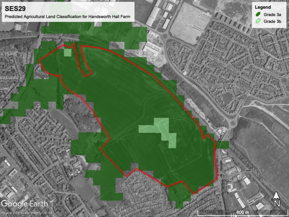
And almost all of the S13 land proposed for release is predicted BMV, as shown below.
SES29 (Handsworth Hall Farm) is predominantly Grade 3a.
SES30 (Bramley Common) is mostly Grade 2, with the rest Grade 3a.
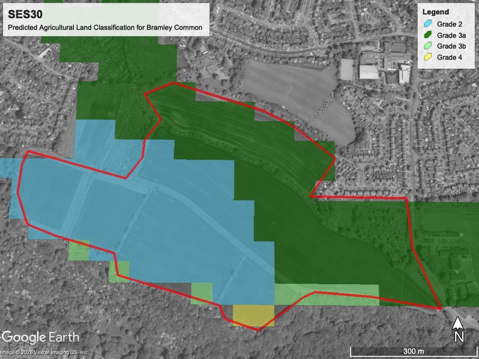
This matters for what the IIA itself says. Strategic Location 1 - containing the Handsworth sites, SES29 and SES30 - is currently scored as only a "minor negative" for soil and land impact, on the basis that the land is "not considered to be amongst the best and most versatile".
On that evidence, the “minor negative” score no longer holds. The impact is now capable of being a "major negative" and it should be reassessed.
By contrast, the site the Council declined to allocate - Ryecroft Farm in Dore - is predicted to be mostly Grade 4: poor-quality land, not BMV.
Clive Betts MP made the same point in his submission to the Inspectors:
"I do not understand why our best farmable land is what the Council seem to be suggesting we develop on first. I raise this especially in contrast to Ryecroft Farm in Dore which ... is predicted to contain much poorer agricultural land."
What another set of Inspectors said two months ago
In March 2026, the Inspectors examining the Central Lancashire Local Plan considered the same arrangement Sheffield is now proposing - deleting site-specific BMV survey requirements on the basis that the matter had been dealt with at allocation stage.
Their conclusion (paras. 23 and 24):
"The Councils should also demonstrate whether, in allocating sites, areas of poorer quality land have been preferred to those of higher quality in the site selection process in order to achieve consistency with national policy on this issue."
Deleting the survey requirement can only be justified if the Council can show it has properly considered whether poorer-quality land should be preferred. Sheffield has not. On the available evidence - its own, and Defra's - it has done the opposite.
Where this leaves the Plan
Three things follow.
First, the claim that BMV impacts have been "taken into account" is not supported by the Council's evidence. The Council cannot rely on an assessment it has not done.
Second, the Ryecroft Farm comparison is uncomfortable. The site discounted from the Plan is on poorer agricultural land than the sites chosen. National policy points the other way.
Third, this question cannot be deferred. Once the Plan is adopted, building on BMV land at SES29 and SES30 is settled in principle. A soil survey at application stage will tell us what we are losing; it will not undo that loss.
For the S13 Campaign, this is the third time in three emails the same pattern has surfaced: figures and findings used to justify Green Belt release that the Council has not reconciled with its own evidence - first traffic, then site capacities, now BMV.
The Inspectors will now weigh the submissions and issue their final report. After that, the Plan returns to Sheffield City Council for the adoption vote.
In our next email, we will continue with how the Green Belt housing has been distributed across Sheffield, and whether the Council has properly justified the distribution it has chosen.
- The Save S13 Green Belt Campaign
What you can do right now
- Share this update: Forward this email to neighbours in S13 who care about our farmland and Green Belt.
- Read the planner’s submission: James Bailey Planning's representation to the Inspectors - the full planning argument on BMV.
- See the maps: The BMV mapping exercise - Defra's predictive Agricultural Land Classification data overlaid on all 11 proposed Green Belt sites, and Ryecroft Farm.
- Read the farmland briefing for councillors: Sheffield's farmland and the Prime Minister's promise.