
The Lahontan Basin
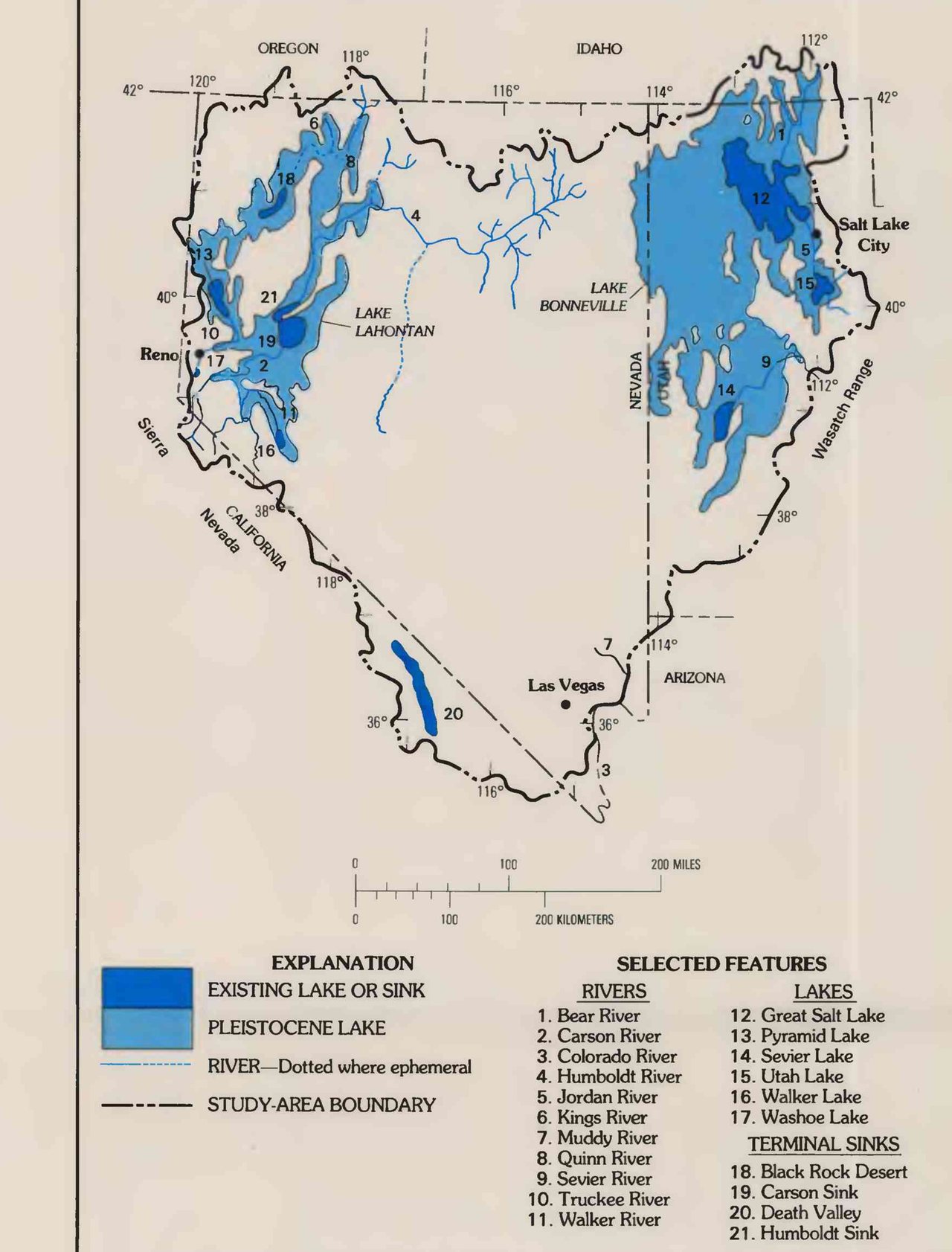
The Carson Sink is a dark-blue shape on that map, number 19, listed under TERMINAL SINKS. Around it, and around Pyramid Lake and Walker Lake and the Humboldt Sink, is a far larger shape in paler blue, lettered LAKE LAHONTAN. The pale blue is a lake that is not there. The dark blue is what is left of it. The man who first mapped the pale shape worked the basin in the field seasons of 1881 to 1883.
His name was Israel C. Russell. He worked for the United States Geological Survey. His book, Geological History of Lake Lahontan, came out in 1885. He names the lake on the first page, “in honor of Baron La Hontan, one of the early explorers of the headwaters of the Mississippi.” He calls it the complement of Lake Bonneville, the lake of Utah. Where Pyramid Lake is now, the water was 886 feet deep. Bonneville overflowed to the north. “The ancient lake of Nevada did not overflow.”
He begins with the country before the lake. The mountains of the Great Basin, he writes, are the crust broken into blocks bounded by faults. Each block is tilted. Its upturned edge is a mountain crest. The Sierra Nevada is the upraised edge of one of them. Its fault is conspicuous “along the west side of Eagle and Carson valleys, from near Carson City southward for fifty miles or more.” The desert east of the mountains is the thrown side. “It is on the depressed side of this fault that the Lahontan basin is situated.”
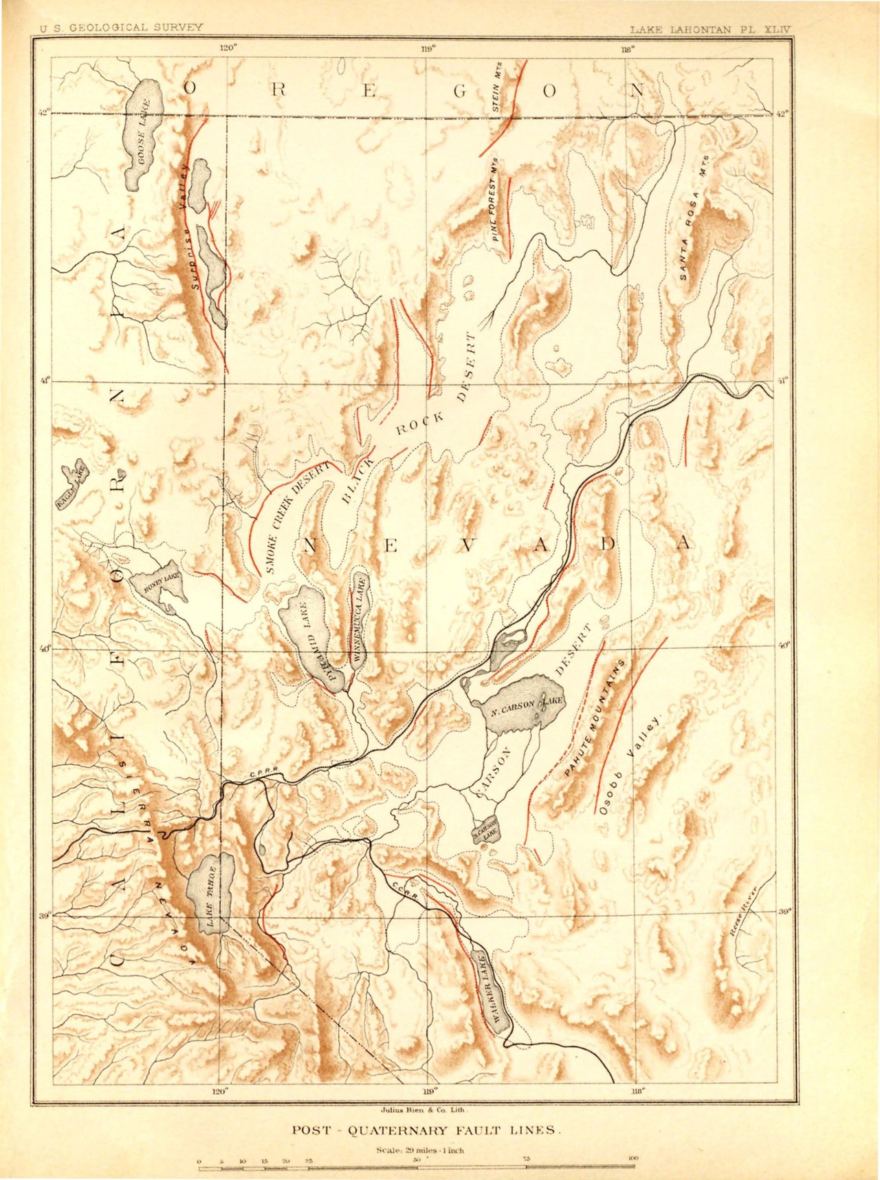
The faults kept moving after the lake came. Their scarps cut the terraces the lake had built. He leveled the highest shoreline at several points around the basin. It did not come out level. The old shore lines “are not now horizontal, owing to the orographic movement that has taken place since their formation.”
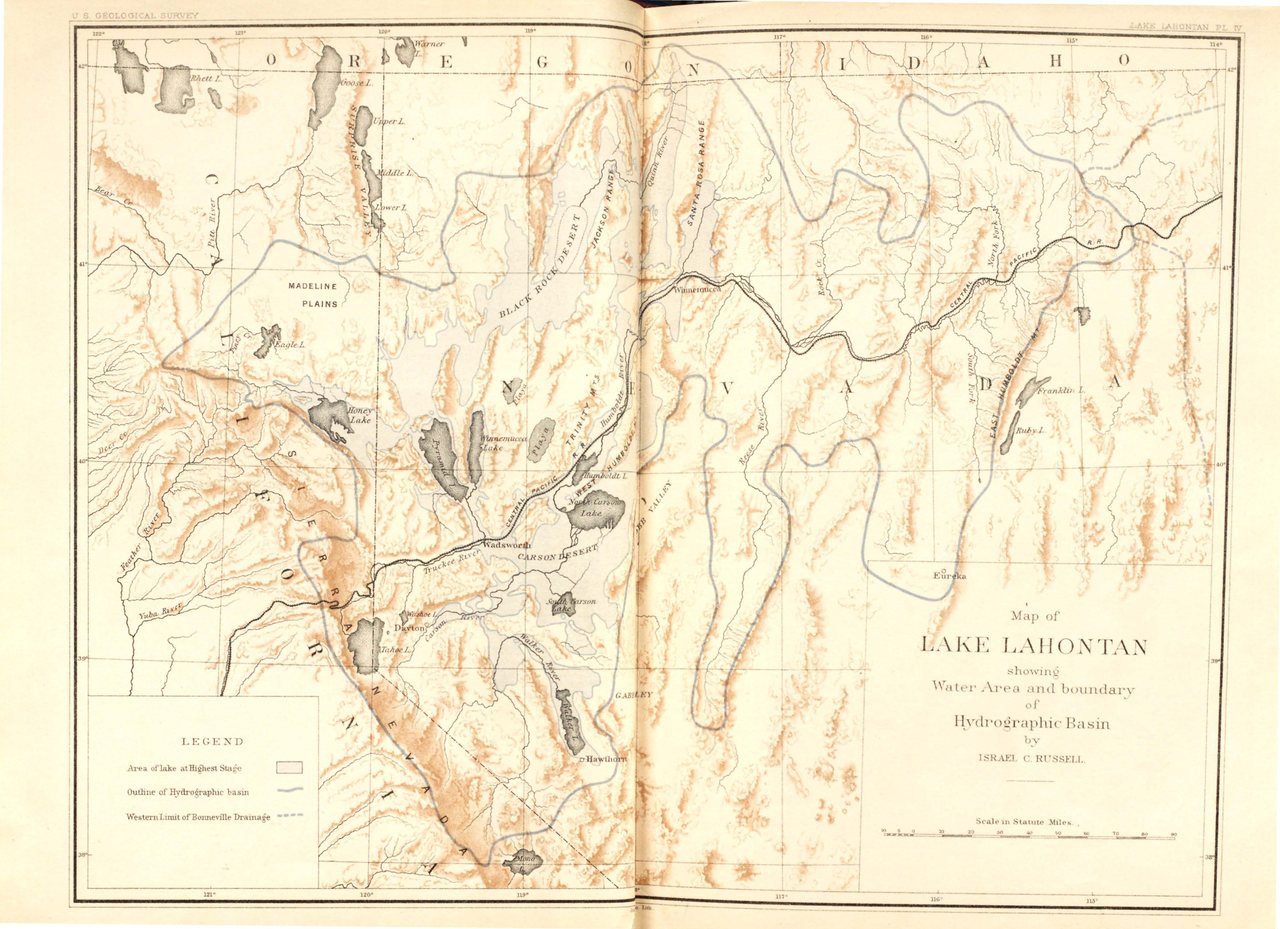
“In traveling over the Central Pacific Railroad between Golconda and Wadsworth, one is seldom out of sight of the long horizontal lines drawn by the waves of the ancient lake on the shores that confined them.” He named the highest line the Lahontan Beach. He leveled it at Mill City. He leveled it at the lower end of Humboldt Lake. He got at it wherever else he could. The readings did not agree. He averaged them and got 4,378 feet, “the nearest approximation we can make to its original altitude.” His barometer put Pyramid Lake at 3,783.
L. V. Benson of the Survey wrote a fact sheet on the tufas of Pyramid Lake. It was published in 2004 with the Pyramid Lake Paiute Tribe. “Because tufas form in lake water, it follows that their vertical growth is limited by lake level.” Benson’s highstand is 4,380 feet. Russell’s beach, averaged, was 4,378. A lake that high was slightly larger than Lake Ontario.
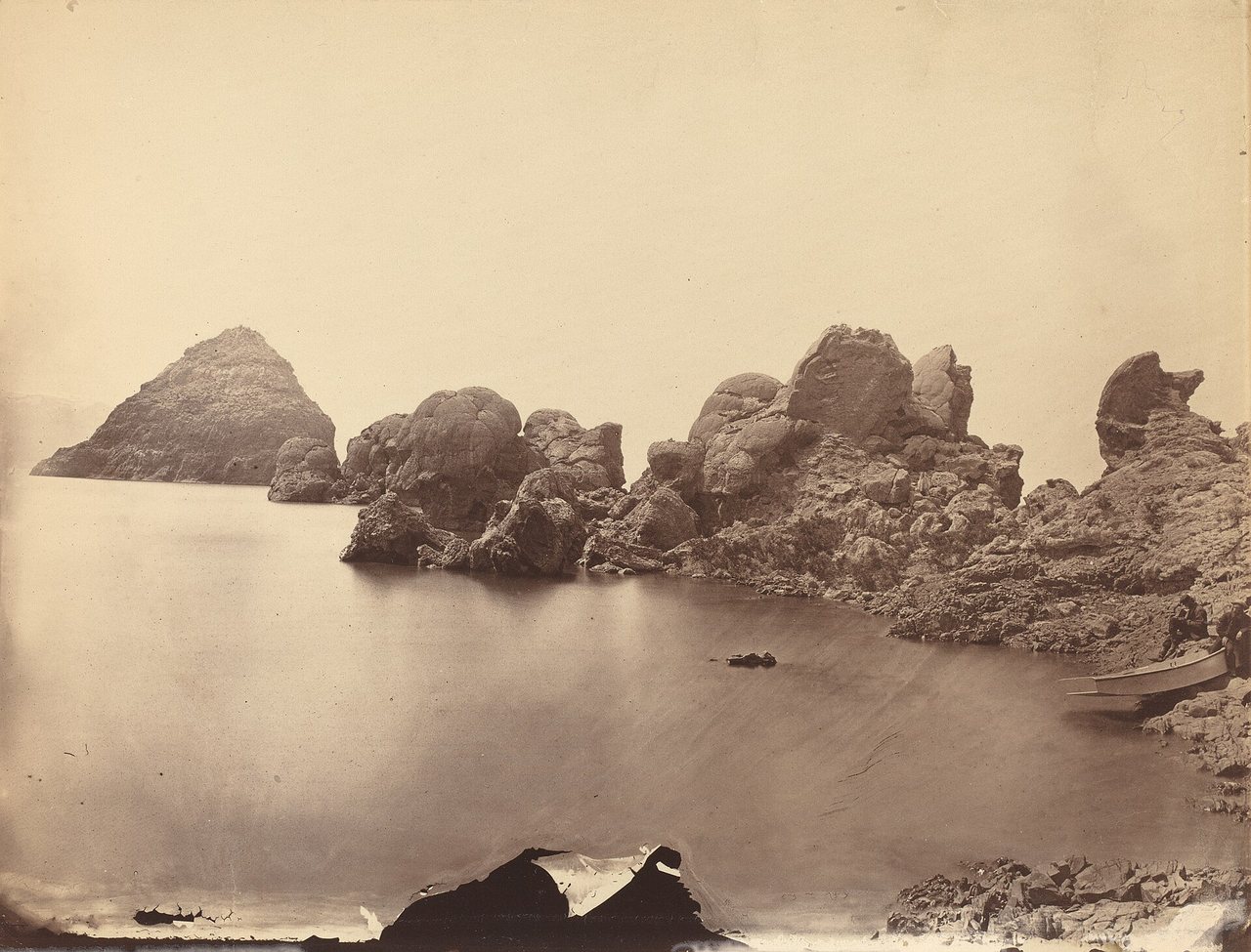
Frémont saw the crust first. The white deposit lay too thick on the mountains along the shore, he wrote, “to have been deposited by water.” The next morning the party camped across from a rock that rose out of the water. It was shaped like the great pyramid of Cheops. It was crusted like the rest. He called the lake Pyramid lake. He gave its elevation as 4,890 feet. Benson’s fact sheet records the Paiute name for the lake, Cui-Ui Panunadu, fish in standing water.
“The Carson River rises on the eastern slope of the Sierra Nevada, south of Carson City, and, after flowing 60 or 70 miles, enters the Lahontan basin through a deep cañon at Dayton.” Measurements at Old Camp Churchill in the first summer of the work gave 450 to 500 cubic feet per second. In the September of his last field season they gave less than half that. He did not have the water analyzed. The stamp-mills upstream had made it not worth the trouble.
Where it ends, the Carson has not made up its mind. Before 1862, the pioneers told him, the whole river went to South Carson Lake. In the high water of that spring it reopened an old channel “and a branch flowed to each lake.” The slough between the two lakes, he was told, has run sometimes north and sometimes south, according to which lake stood higher. Slight willow dams at the forks regulate the split. “While viewing the Carson Desert from the surrounding mountains one may trace, as on a map, the various branches of the river meandering through the monotonous plain, by the lines of vivid green cottonwood trees that mark their courses.”
The lake rose twice. The second time it went 30 feet higher than the first. It did not stay long. It went down for good. “The waters continued to fall until the basin was completely dry.” Out of its beds came the bones of a horse, an ox, a camel, an elephant or mastodon, and “a single chipped implement of human workmanship.” The living lake “is abundantly supplied with splendid trout.” Professor Cope’s list of its other fishes includes Chasmistes cujus.
He puts a date on it. The dry time after the lake “was finally terminated—probably less than 300 years since—by an increase in humidity. The present lakes then commenced their existence.” He reasoned it from how fresh the water still is. I would have too. Benson had radiocarbon. He has the lake rising sharply about 26,000 years ago. Overflow to the Carson Desert held it a long while. It fell fast after a highstand some 15,000 years ago.
The water that reaches the Carson Sink now starts a long way up, at Llewellyn Falls, on Silver King Creek. Walter Thornburg wrote in 1933 that “the falls are over granite rocks.” James R. Giusso drew the Survey’s geologic map of the Sonora Pass quadrangle. He maps the rock at the falls as the Stanislaus Group, Tertiary volcanic rock. Nothing granitic. The Survey’s lidar has the creek dropping 16.5 meters in the 400 meters through the falls.
From there the water goes to the East Fork of the Carson, to the Carson, through the cañon at Dayton, past Lahontan Reservoir, to the Carson Sink. On the 1988 map the Sink is dark blue inside the pale blue: number 19, a terminal sink.