5% of Sheffield's Green Belt, 35% of the loss
The Further Main Modifications consultation closed on Wednesday 28 October. Thank you to everyone who wrote in and we'll report separately on what the campaign and the Sheffield Green Belt Alliance submitted to the Inspectors.
This email is about a figure the Council gave twice in the last week: that Sheffield's part of S13 would lose about 29% of its Green Belt. But that number does not show how concentrated the loss is.
We have set out the figures, a map and how we calculated them on our website: S13's Green Belt: what we stand to lose.
Where the 29% comes from
On Monday 26 October a briefing sent to all councillors on behalf of the Head of Planning said Green Belt in Sheffield's part of S13 would go from 469.49 to 335.60 hectares: a loss of 133.9 hectares, or about 29%.
Then, on Thursday 29 October, The Star reported the Council’s figures for Sheffield’s part of S13. The Council put the reduction in Green Belt at around 29%. It also said the Green Belt sites proposed for development represent about 3.5% of Sheffield’s Green Belt.
Those figures describe the city, or the postcode, as a whole. None of them shows where in the city the loss is heaviest.
S13's share of the city's loss
We measured the Council's Main Modifications Policies Map against every Sheffield postcode district.
S13 holds about 5% of Sheffield's Green Belt. It would take about 35% of the Green Belt the city proposes to remove.
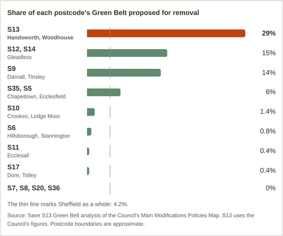
The Council's 3.5% counts only land allocated for development. The 4.2% in our chart counts all the land the Plan would remove from the Green Belt.
The west and south-west of the city (S6, S7, S8, S10, S11 and S17) hold about 3,900 hectares of Green Belt and would lose about 28. S13 holds about 470 hectares and would lose almost five times as much.
Measured per resident using 2021 Census data, each S13 resident stands to lose around 43 square metres of Green Belt - compared to a little over 1 square metre per resident in the west and south-west.
Within S13, one area around Handsworth
Almost all of S13's loss is concentrated in one area in Handsworth, where the Plan allocates two areas of Green Belt for development:
- Handsworth Hall Farm (SES29): 56.4 hectares, for 870 homes and 20 hectares of employment land.
- Bramley Common (SES30): 35.28 hectares, for 827 homes, with land safeguarded for a school and a burial ground.
Together that is 91.7 hectares, about the size of Graves Park. The 1,697 homes are about 43% of those planned on Sheffield's Green Belt housing allocations.
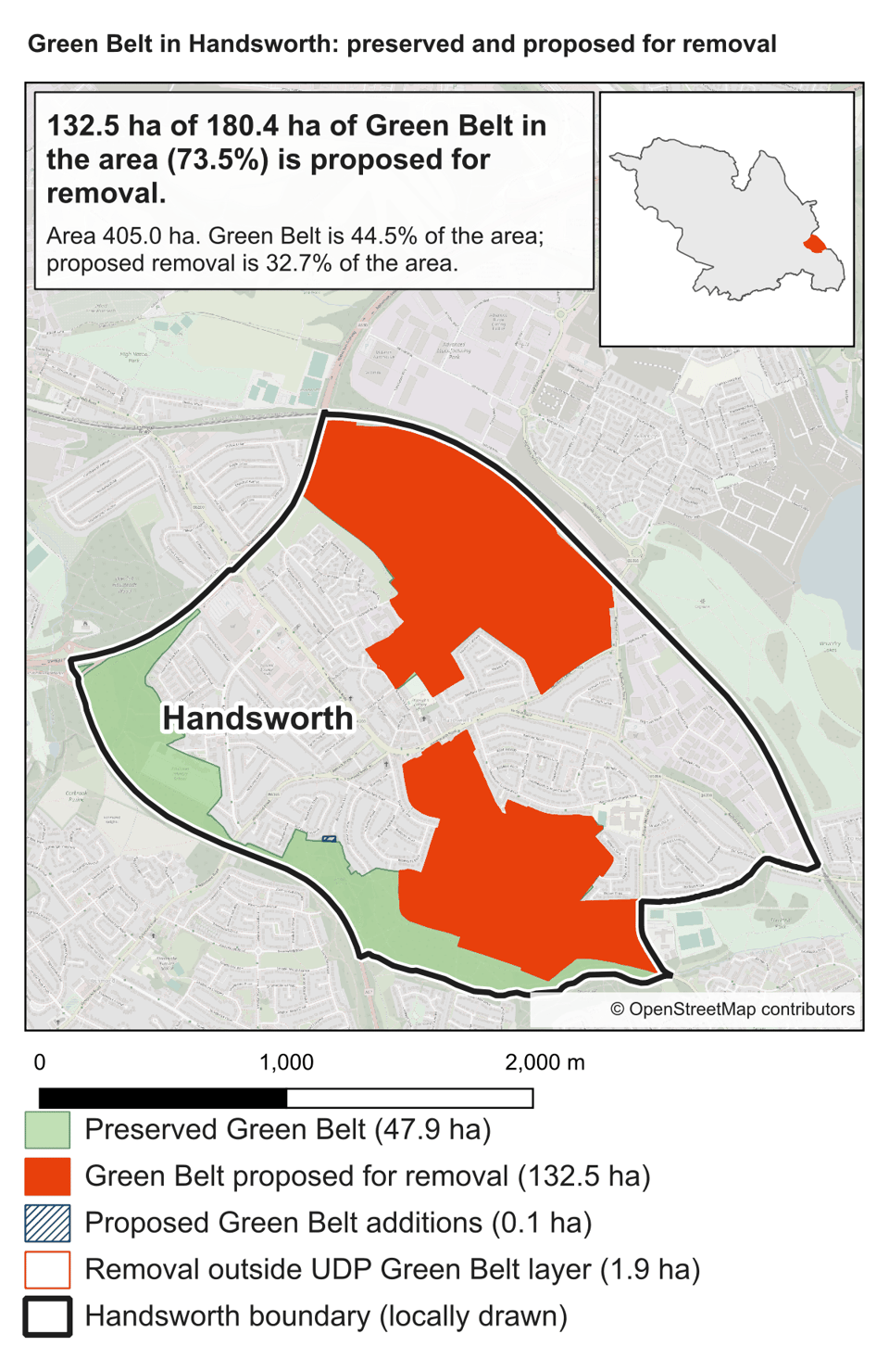
In the area on our map, 132.5 of 180.4 hectares of Green Belt would be removed, or 73.5%. This is the total loss of Green Belt designation within our outline. It includes the two development allocations, which together cover 91.7 hectares, and other land outside those allocations.
We drew the north-western outline to follow the Parkway. Others may draw it differently and perhaps include the Triangle and Clifton estates. Even so, almost all of the 133.9 hectares S13 would lose is inside those boundaries.
"Protected from development"
The briefing also told councillors that land becoming Urban Green Space Zones would "continue to be protected from development".
Urban Green Space Zone status is not the protection the land has now as Green Belt, or the protection national policy gives "Local Green Space". When the Council takes land out of the Green Belt and wants to keep it open, it can consider two designations:
- Local Green Space is protected by national planning policy. Proposals to build on it are decided against the same policies as Green Belt. It can be designated through the Local Plan.
- An Urban Green Space Zone is protected by the Council's own policy. Proposed Policy GS1 allows green space in these zones to be built on if it is judged surplus to requirements, or if equivalent space is provided in a suitable location. A future Local Plan could also redraw the zones without the exceptional-circumstances test that applies to Green Belt.
The Council has chosen the weaker of the two.
We have already seen how it uses the word "surplus". The open space behind Beaver Drive is part of Bramley Common (SES30). It is Green Belt, many people use it, and the Council's ecology reports record at least six veteran trees along the stream there, classed as "irreplaceable habitat".
The Council's site assessment deems the land "surplus" - conveniently opening up access to the larger agricultural fields beyond - despite similar open space elsewhere in the city being excluded from development.
So "protected from development" still leaves a route to development through a "surplus" assessment. At Beaver Drive, the Council’s site assessment already applies that label to the open space.
If the Council wants to protect this land, it can propose Local Green Space designation. It has not explained why it has not.
What happens next
We will be asking questions at the next Full Council on Wednesday 4 November. A vote to adopt the Local Plan will come after the Inspectors' final report, which the Council expects at the end of this year or early next year.
Councillors who vote for the Plan will be approving where the Green Belt is lost. They should have these figures before they vote.
What you can do
Read and share the page. S13's Green Belt: what we stand to lose has the map, the figures for every postcode, and how we calculated them.
Write to your ward councillors. You can find your ward councillor here. Ask them two questions:
Why would S13 lose about 29% of its Green Belt, while the west and south-west lose under 1% of theirs?
Urban Green Space can be built on if the Council judges it surplus. If the land around Handsworth is to be "protected from development", why has the Council not proposed it as Local Green Space?
Forward this email to a neighbour, or to anyone who wants to understand what the postcode-wide 29% figure means for the area around Handsworth.
-The Save S13 Green Belt Campaign