Thanks to everyone who has helped fund me to go to the Ocean Sciences Meeting later this month—your donations are helping a lot financially (and emotionally) to get all my PhD work out in the world! Also, if you want to get a big-picture idea of how wetlands and sediment resources have evolved over time in San Francisco Bay, consider attending my webinar for the American Association of Geographers: The Wetlands of San Francisco Bay: Shifting Sediments and Murky Histories.
For me, now is an interesting time to return to my work on this marsh. While my current project is much more about (freshwater) wetland hydrology, my previous work is closer to coastal engineering. The difference between these things can be typical academic hair-splitting, but at its core, engineers are "scientifically-trained technician[s] in public service," according to this history of coastal engineering. Coastal engineers are a subset of civil engineers focused on coastal processes. Engineers have a nerdy focus and applied, beneficial intent: in my work, it was about understanding the technical details of successful marsh restoration.
"Coastal Engineering" as a distinct discipline is a relatively young field in the USA. As that history document linked above attests, people have made technical decisions to modify the coasts for eons, often towards maintenance of ports, but the field only became somewhat codified in the first third of the 20th century. Coastal engineering splintered off of civil engineering when American beaches began eroding, as they suffered the long-term consequences of jetties installed on beaches and dams installed upstream, and money was put towards management of these problems. A heavy injection of research money then came from the military during World War II, to research wave conditions to plan the Normandy Landings. This influx of purpose and organizing caused decades of ripple effects in coastal engineering, allowing the field to mature in the 50s, 60s, and 70s. Because they have jurisdiction to manage most of the coastal waterways and coastal protections in the United States, The Army Corps of Engineers is one of the leading institutions of the field: their 1984 Shore Protection Manual is still (!) a go-to reference.
But it's been more than 40 years! Workforce needs have changed, academic life has changed, and our coastlines have changed a lot since the 80s. Despite this, many degree programs in coastal engineering have atrophied. UC Berkeley was a leader in the field in the 1920s-30s but now hasn't really touched the discipline in decades. I somewhat approximated it while I was there: my advisor worked on estuarine physics, I took classes in waves & oceanography at UC San Diego, worked with a professor in coastal oceanography at UC Davis, and spent some old-fashioned time reading textbooks. Today, I think only two schools remain that explicitly grant Bachelors' degrees in coastal engineering: UNC Wilmington and Salisbury University (let me know if I'm missing any!) A handful more offer coastal engineering courses within civil, or as a "track" within civil engineering, or degrees at the graduate level: University of Florida, NC State, Texas A&M, Oregon State U., University of Delaware, etc. Some roll it into Ocean Engineering, which blends more with oceanography and marine architecture. Regardless, the state of training for the discipline is somewhat absurd: with increasing populations on our coasts, increasingly constrained sediment resources, worsening storm regimes, and rising sea levels, we absolutely need new coastal engineers!
As I pivot myself out of academia—I would like this postdoc to be my last—I have been thinking a lot about what a coastal engineer for the 21st century needs to do. On top of the basics, what should a coastal engineer know? How should they think? (What should I do to get there!!??)
Here, I'll explain a few categories of ideas I have.
1. Sea Level Rise
This is a no-brainer. Sea levels have been going up since the last glacial maximum, so for thousands of years—but they have been accelerating in pace due to human activities leading to ocean warming and glacial melt. Explicitly planning for rapid sea level rise (SLR) has only been happening for a couple decades, and rarely sufficiently for effective management, like managed retreat. Today's coastal engineers need to take SLR as a given for the coming centuries, and learn to think with it.
Effectively accounting for SLR requires knowing the main drivers of the processes, and how SLR varies across space and time—some places will be more affected than others, sooner or later than others, and in different relative terms! This typically depends on how tides change nonlinearly with sea level, or geologic conditions like subsidence or post-glacial rebound. SLR projections themselves are complex: users should know what assumptions they make, what models they use, and how to best localize them to specific project sites.
TL;DR: Sea levels are rising, but how fast depends on local factors and nuanced modeling that coastal engineers must understand to plan with effectively.
2. Extreme Hazards & Compound Flooding
Sea level rise is a form of "slow violence," growing over centuries to haunt us more and more. (Or sometimes leading to worsening tidal flooding, as we see happening in places like Miami.) But on top of that, anthropogenic climate change is leading to more intense and more variable storm regimes, leading to more catastrophic storm events like Hurricanes Helene and Beryl in recent memory.
Storms cause rain, which can fill rivers and cause flooding, but their winds cause waves and their low-pressure systems increase water levels—and these effects lead to what we call "storm surge," or increased coastal water levels associated with the atmospheric system. When we quantify storms, it's common to say things like "100-year storm"—which means the historical records suggest a storm of similar intensity has a 1/100 chance of happening in a given year (see a good explanation of this return-interval math here).
But these numbers are increasingly not true. The models behind them have always been limited by data—we only started keeping good records when we could, and few records are longer than 100 years!—but at the core, the regimes are changing. What was a "10-year storm" in 1990 has become more common in 2025. The statistical distribution of the intensity of storms (and the flooding they cause) has shifted over time—scientists call this "nonstationarity."
21st-century coastal engineers need to acknowledge this statistical reality and keep up with developments to move beyond the "N-year storm" model. This gets really tricky: we need to invent synthetic future events, rather than look at our observed historical records, to understand what is coming, but we have improving methods to do so.
Secondly, most engineers get some statistical training. But extreme value theory, the analysis of statistical extremes, is not always included. Extreme value theory is crucial for interpreting and expanding this work on extreme events, which are almost always what coastal engineers are most worried about. These theories are also a new field—some early research emerged in the 20th century—and civil/coastal curricula should prioritize teaching it immediately.
Lastly, while coastal engineers are typically concerned with extreme waves, extreme tides, and extreme river flows, the worst events happen when all of these occur simultaneously to create extreme flooding (i.e. water levels, wave damage, currents). We often have understandings or statistics of each part individually, like statistical distributions of river discharge and good tidal predictions, but it is complicated to bring them together. While numerical models help, we may be able to plan faster by thinking statistically, but it is not always intuitive how to bring together multiple statistical distributions that are not independent (I think "copulas" are a tool for this??? Where are my statisticians!) We need to learn good conceptual models to aggregate what we know towards assessing "compound flood" hazards, which are increasingly the focus of extreme event analysis.
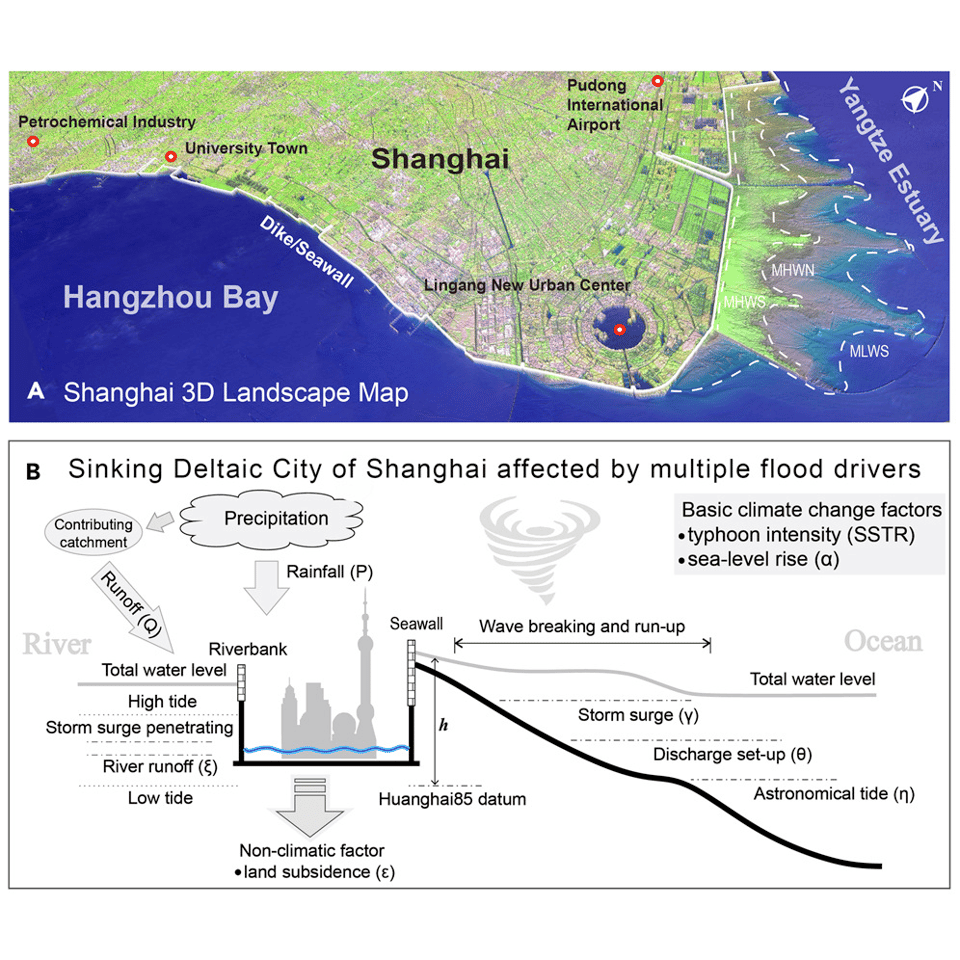
From Zhang et al. 2025, One Earth.
TL;DR: Using historical records to represent hazard risks is losing its power, we need to engage with extreme value theory and compound flood risks.
3. Adaptive Planning
The idea behind adaptive planning is that we need to be thinking about a cohesive roadmap forward, rather than get caught off-guard by an extreme event. Instead, we should be responding to warning signals. Because we don't know exactly how emissions will be curbed, people tend to flail around saying "when will we hit 1 meter of SLR? Because we don't know, we'll do nothing!"
Indeed, it's impossible to know for sure! Adaptive Planning says: we can made flexible plans that adapt to how fast we get there.
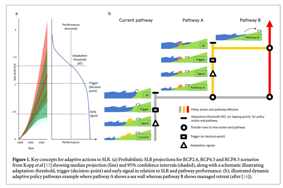
From Stephens et al. 2018, Environmental Research Letters.
Perhaps we stick with business-as-usual until we meet 20cm of SLR from a year 2000 benchmark. Then we begin planning and engineering work towards the 50cm benchmark, which is surely coming. But if we get there, and saline intrusion is less bad than we anticipated, we can modify our plans to account for such. Setting up a system of early warning signs, thresholds to spur new actions or plan-making, and pathways to respond to pressures as they arrive really helps clarify what actions are urgent, and how a combination of small actions can lead to big effects long-term. I would much rather this than just waiting for one big hurricane to happen and only then start the process of improving drainage. It's a shame so much disaster-response money is disaster-response, rather than disaster-prevention. We could also use more pro-active buy-out programs. Shoutout to my friend Kelly who runs Buy-In Community Planning. Coastal engineers need to be thinking in modes of adaptive plans, rather than as fixed "big projects," and get experience putting them together to assist with successful coastal adaptation.
TL;DR: Plan pro-actively about what thresholds of risks will trigger next steps of action, rather than trying to fix everything at once, or in a response to a catastrophe.
4. Ecosystem Restoration & Working "With Nature"
This one is dear to my heart, as it was my motivation for changing careers and going to graduate school. The idea is that for us to reduce the risks of anthropogenic climate change and potential damages to structures on our coastlines, we need to be restoring ecosystems. This typically brings myriad benefits: replacing a seawall with a wetland can provide the same flood protection while also sequestering carbon and supporting biodiversity. Plus, if done right, a wetland can be self-sustaining, instead of a concrete wall that needs replacement every 50 years.
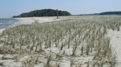
Habitat restoration work has been going on for a while, in many different looks and flavors. There is a relatively large body of literature in river restoration—how to do it well and how not to do it well—which is something that us coastal practitioners can learn from. Coastal restoration is about as young as coastal engineering in the USA: there were sand dune and beach grass replanting efforts in the 1930s, and the Army Corps of engineers began to value beach restoration in the 1950s, as they realized beaches can protect property just as well as seawalls. The differences is that beaches are dynamic, constantly shifting as 3-dimensional landforms, and thus more difficult to quantify and "engineer" int performance versus hard, fixed structures.
Formalizing approaches to get "green infrastructure" and constructed habitats to work in coastal engineering has been a key part of efforts like Engineering with Nature. Here, the goal is to use normal processes of habitats and ecosystems—whether natural or restored—to effectively "do" engineering work. Not all of this is coastal, but many novel projects have come from coastal work. We have realized that coastal landforms and ecosystems have evolved to preserve themselves against the forces of the ocean—so let them do the work!
One of the most famous large-scale examples is the "Sand motor" near The Hague, in the Netherlands. Instead of doing regular beach nourishment, where sand is trucked or dredged to widen a beach at great costs and logistics, the regional water board elected to do one mega-dredge and placement (which reduced costs & environmental impacts) and let the sand naturally drift up the coast by prevailing winds and currents, nourishing the beaches for decades. It seems to be mostly working, from what I can tell.
Restoration and working with nature are amazing in theory, but can be tricky in practice. Regulations are less often ready for these types of interventions, and review boards may be less tolerant of fuzzier or dynamic risks (i.e. it's easy to quantify how a jetty will protect from waves; a beach will do so more variably). Working-with-nature projects may have high up-front costs that only pay off with lower long-term maintenance regimes, but the opposite might also be true if the physical and economic conditions aren't right.
TL;DR: Nature can do a lot of work for us as coastal engineers, if we let it and make restoration a priority. Coastal engineers need to be thinking "with nature" and studying how to make this easier and less complicated.
5. Not Just Beaches
Our coastlines take many forms. Some are rocky, some are made of sand (beaches), and some are made of mud (wetlands). The rocky shorelines are actually some of the simplest as they are the least dynamic, although cliff failure is interesting. That aside, coastal engineers of the previous century have been largely fixated on beaches. It is on beaches that early coastal engineering developed, beach recreation is an enormous economic engine in many places, and beaches often fill an outsize place in our conceptual of what the "shore" is. Our understandings of how sand moves around and how sand become beaches or dunes is fairly good.
But!!! Let's not forget the muddy wetlands!!! Just because people don't like to recreate in mud as much as on sand does not mean they should be neglected. Wetlands are much better than beaches at carbon sequestration and as bird or fish habitat. Engineering expectations and scientific understanding of how fine sediment (aka mud) moves through environments, and how muddy landforms evolve over time, are much worse than that of beaches and sand. (It's also more complicated, I think, and there's some basic science to be done.)
Coastal engineers for the 21st century need to understand fine sediments as much as they do coarse, and acknowledge that they can engineer with wetlands just as has been done for beaches. This implicates more nuanced sediment management, like considering the different fates of sand and mud when doing things like beneficial use of dredged material.
TL;DR: Coastal engineers should be ready to work intelligently with mud and muddy landforms, as we acknowledge their value more than ever before.
6. New Toys
Beyond these conceptual approaches, new coastal engineers have a set of technical techniques that have emerged since the 80s. The biggest of these, in my opinion, are amazing advances in remote sensing (aka satellite imagery), giving us information about lots of properties of the globe, somtimes at daily timescales. Additionally, research-grade drones are now a thing, allowing us to more easily collect imagery (and maybe even LiDAR) at relatively low costs for site-level work. With these images, we can more easily monitor natural site conditions (e.g. shoreline dynamism), and do monitoring on engineering interventions after they are made.
We now have more long-running datasets in monitoring, like the Long Term Ecological Research effort, of which some sites are coastal, and CDIP at Scripps, which has wave data across the USA (particularly southern California). These datasets have pushed forward science that advances what to expect in coastal systems, especially useful in restoration and "with-nature" projects. In the background, climate modeling has advanced by leaps and bounds in 40 years. Coastal engineers may not be collecting these data or running these models, but they should be aware of what's out there to make informed engineering decisions.
One key sensor for coastal workers, particularly for work in places with complicated hydrodynamics like estuaries, are Acoustic Doppler Current Profilers (ADCPs). These devices, which grew into popularity in the 80s and 90s in particular, can detect 3D water velocities throughout a column of water. These are now fairly ubiquitous, but I think coastal engineers need to know how to use them or the data they produce. We should be paying attention to advances in sensor technology and platforms that allows us to more easily characterize coastal conditions, whether professional-grade or DIY.
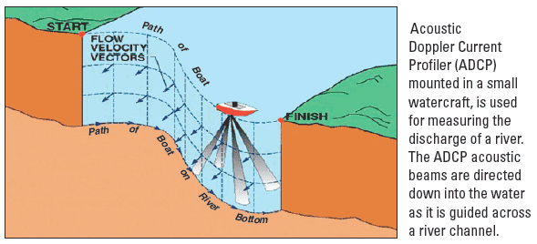
Via USGS webpage.
Lastly, although it could be a complete post of its own, is advances in coastal modeling. There are now many suites of software for modeling coastal conditions in different ways, and coastal engineers need to have a grasp on their general principles as well as experience with a few. I, shamefully, only have a little experience in running SWAN, but I would like to carve out some time later this year to get to know it deeper, or another model. In present-day, advances in machine-learning techniques are changing how modeling is performed and speeding up operational performance. It's perhaps a bit too soon to expect the average coastal engineer to know how to do this all too, but it's all useful to know in building skills for the 21st century.
TL;DR: Satellite imagery and advances in modeling are helping with monitoring and prediction a lot. Field work is necessary but hasn't changed much recently.
Whew! This list essentially became my own self-ascribed curriculum as I try to become a coastal engineer. But I'd love to hear from you readers what you think I might have missed. Also, obviously, I've kept things pretty technocratic: recent decades have led to lots of change in participatory methods in planning processes. Public hearings and planning participation are big components of the daily life of coastal engineers. If I was purely advising how a curriculum in coastal engineering should be today, we would also need to learn about communication of engineering thinking, engagement with diverse stakeholders, and facilitating great public participation in planning and engineering processes.
The post is long, but I am inspired to put these ideas in practice in honoring that tradition of "technical expertise in public service." We need to bring it all into the 21st-century to keep our field from atrophying further.
Adaptively planning my career,
Lukas
You just read issue #103 of Gnamma. You can also browse the full archives of this newsletter.