Forever on Our Mind: It's Always Sunny at Smith Rock
In which our fearless hero faces his fear of heights—and learns a little something about his home state along the way
48. It’s Always Sunny at Smith Rock
October 2014:
Cowboys shepherd herds of cattle across the dusty Central Oregon steppe of my imagination. There, tumbleweed rolls, sluggish, across the barren freeways; rock formations withstand millennia of long, hot summers and bitter, cold winters; and cinnamon-shaded ponderosa pine trees loom over the high-desert expanse of the Wild West.
This fantasy arose from the only two times I traveled east of the Cascades. That first experience in the fall of 2011 consisted of little more than a day trip to the Painted Hills; nearly two years later, a few friends introduced me to the community of Sunriver. With views of snow-capped Cascade peaks, forests of ponderosa pine, lava flows coursing through town, and high-desert landscapes at its doorstep, Sunriver bore little resemblance to the forested Willamette Valley with which I was so familiar—and the Oregon I knew. That four-day trip in 2013 laid bare how little I knew of the state I called home and proclaimed to love: If Sunriver hosted this much beauty, what more did the sun-kissed region have to offer?
On this October Saturday, I decide to find out. After an early lunch, I make my way through Portland, cross the Cascades, descend toward the high desert and rimrock canyons of Central Oregon, and arrive—with a slight chill in the air and the sun on my shoulders—at Smith Rock State Park.
I’m here specifically because, just six months ago, Smith Rock was dubbed one of the Seven Wonders of Oregon by the state’s official tourism commission. What better place to connect with the sunny side of the state than by visiting one of its top sites—with views of sunbaked rock formations, mountain peaks, and perfectly manicured farmland splaying out in every direction?
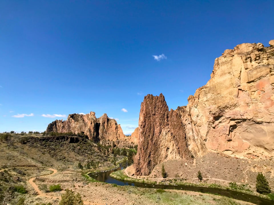
I park in the easternmost lot, look over the Crooked River, and—sure enough—take a deep breath at the sight before me. Jagged summits rise from the sheer rock faces like an erratic EKG. Hiking trails crisscross the formations and forests below. I think I spy a few rock climbers on the park’s daredevil routes. The Crooked River ambles through it all.
As I’ll find out later, the natural processes that eventually formed Smith Rock began, some 26 million years ago, with the largest volcanic eruption ever to take place wholly within Oregon’s borders.
Smith Rock’s famous rock formations reside today at the northern edge of the Crooked River caldera, a 26-mile-long ancient supervolcano that left behind what I think scientists might call a “shitton” of rhyolite ash debris, which eventually hardened into rock that would become the park’s signature tuffs.
Fast forward to roughly 400,000 years ago, and basalt flows from Newberry Volcano traveled roughly 75 miles and, at their northernmost reaches, covered much of that ash. Millennia of erosion, along with the stubborn Crooked River refusing to flow anywhere else, led to the site before me.

That sense of awe dissipates as soon as I look over the Crooked River and eye the hillside rising from its shore with the kind of weary suspicion typically saved for door-to-door Jehovah’s Witnesses. A handful of hikers ascend the trail that cleaves the hillside like a scythe, mere inches from a steep drop-off that falls hundreds of feet into the river below. The trail appears to rise at a 45º angle, which seems a little impossible and extremely unfair. For all the enormity of the high desert, the ridge-hugging trail looks positively claustrophobic from my car.
My crippling fear of heights may yet tether me to the low-lying trails that parallel the riverbank, but that terror yields to a recurring reverence as I descend to the canyon floor. I walk amid gnarled juniper branches twisting in every direction, sun-stained shrubs, and soft dust that flecks my glasses after a few steps. The rocky hills surrounding me glow with a warm, desert hue that envelops my surroundings like a real-life Instagram filter. I see a few climbers navigating the sheer cliffs before (and above) me; in the 1980s, Smith Rock gave birth to sport climbing in the United States and remains a premier climbing destination today.
I cross the Crooked River at the base of the canyon, look at my map, and don’t see a viable route that circumvents Misery Ridge, the 1,000-foot hillside trek that unnerved me from the comfort of my car. Safety first, I reason internally, in an attempt to skip Misery Ridge. But I can’t justify the seven-hour round-trip without seeing the view through. Besides: If those climbers can scale this wall with only ropes and friends to support them, I can probably put one foot in front of the other long enough to do the same. So I start my ascent.
Four minutes and seemingly 2,000 feet of elevation pass before I take my first water break. I’m nowhere near the steep straightaway that uncorked dread in my stomach’s pit, and for the first time I finally internalize what it means to climb a thousand feet in one excruciating mile. (For context: It’s roughly the same as climbing Portland’s tallest building—the U.S. Bancorp Tower—twice.)
The trail eventually straightens out and follows that much-feared, appropriately named ridge above the Crooked River. No ropes or guardrails offer assurance that I won’t fall to my death in the canyon below. Don’t look down, I mutter under my breath.
I arrive at the top of the hillside after a deliberate slog and assume—naively, as I’ll soon discover—the worst is over.
Another set of switchbacks return after a few more stops for water and prayer. At this point, the trail alternates between steep, craggy scrambles and endless flights of wooden stairs. A friendly hiker on her way down invites me to pass, but I insist: No, no—I’m hugging the rock face more for myself than for you. Frodo and Sam endured less while entering Mordor.
I scramble desperately to the top of the bluff after what feels like hours, sit on a smooth rock, and finally behold a Central Oregon even better than the one I dreamed about.
The azure Crooked River traces a “U” shape through the khaki-colored canyon, thick pine trees line its banks, and a few clouds linger overhead, seemingly close enough to touch. Gnarled juniper, rocks the color of light beer, and towering rocky formations, their craggy spines resembling an erratic stock market chart, fill in the rest of the landscape. To the west, bright green patches of farmland sit beneath the likes of Black Butte and Mount Jefferson—both struggling to be seen behind dark clouds that will bring a rare rainstorm to the region. In a moment that would seem too hokey for fiction, I spy a tumbleweed somehow rolling carelessly uphill.
Even after decades of living just across the state line, and after a year of calling Oregon home, I still associated the state’s beauty with the idyllic Crater Lake, impressive Multnomah Falls, and a rugged coastline—forests and landscapes shaped by rain, more or less. But, upon arriving at the summit of this windswept bluff, I see the small-mindedness of those fantasies. Here, in what seemed like the middle of nowhere a few hours earlier, the unforgiving desert, tree-lined canyon, and peaceful Crooked River all nudge up against each other, all the way to the ends of the Earth.
It’s better than the sunny settings in old Clint Eastwood movies, more fascinating than the scenes I’d conjured, more beautiful than any photo could capture. It’s real.
This newsletter is free—but if you enjoyed this essay and would like to support my work and travels around Oregon, you can make a one-time or monthly donation at Buy Me a Coffee or via the button below:

And if you’re not already a subscriber, you can learn more about “Forever on Our Mind: 1,859 Love Letters to Oregon” and click the button below to subscribe to this weekly email: