Hiking the Pogosta Loop
Rainy days walking a 90 km circular route with a mix of forest roads and scenic trails.
I hiked Pogostan kierros, almost anyway. It's a circular 90 km hiking trail in Ilomantsi in Eastern Finland.
I chose it because it's easy to get there from Helsinki by public transport. Take a train to Joensuu1, then take bus 480 to Ilomantsi. Get off at the Parppeinvaara P bus stop. In theory, you could hike the connecting route to the trail. In practice, you need to navigate a bit — more on that below.
Let's start with what it was like: it sucked. It mostly rained and the temperature was about three degrees Celsius. While there were beautiful eskers and old-growth forest, there was also a lot of walking on roads through clear-cut commercial forest. If you want just the good parts, do Taitajan taival instead.
Itinerary
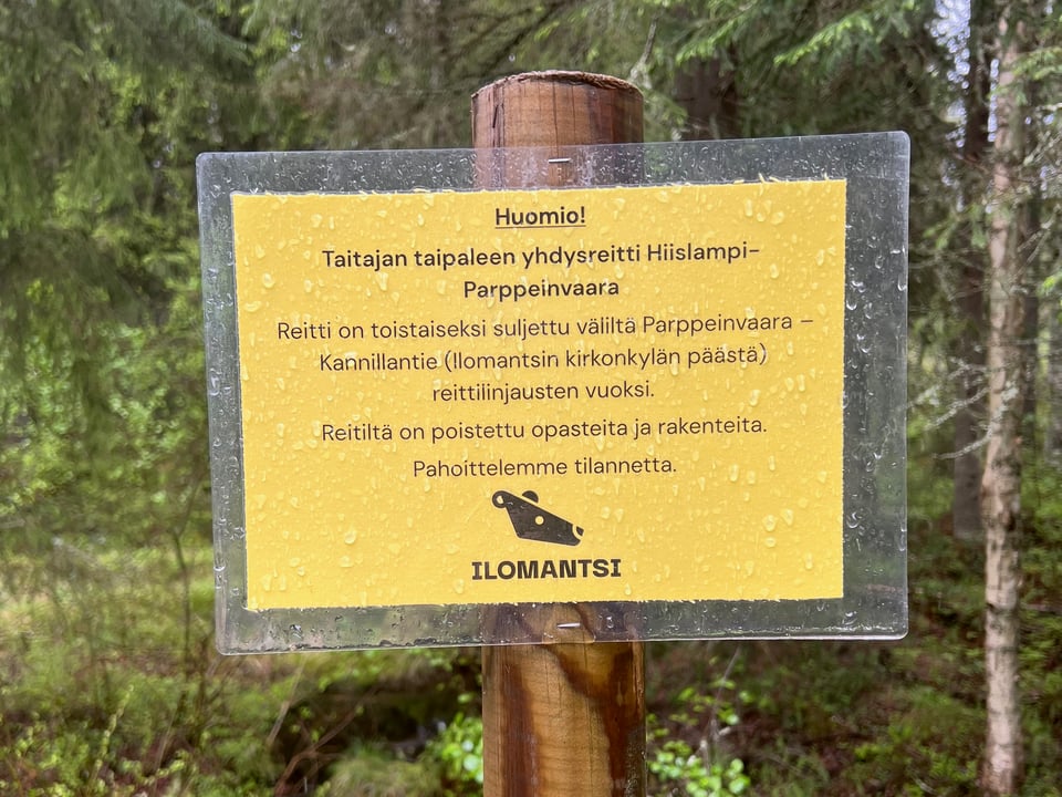
Day 1: I hiked from Parppeinvaara to Tetrijärvi lean-to. The connecting route starts in the back yard of one of the cottages at Parppeinvaara. There are no signs, but look for bright orange paint dots on the trees.
The connecting route is out of use right now. They've clear-cut an area in the middle of the route and the path is gone. In practice you're still able to hike it if you're willing to navigate a bit yourself.
You almost don't need a map on the Pogosta loop — just follow the bright orange dots.
I passed Hiislampi lean-to and stopped at Tetrijärvi. All the lean-tos in the area are in good condition and stocked with firewood. All of them have a dry toilet and most of them have trash cans.
Most lean-tos have a lake close to them, with the exception of Kiieskangas and Ölkönlampi2. You probably shouldn't drink the lake water as is, but I'm fine with using it for cooking. Boil it!
Day 2: I hiked all the way to the Pohjoinen Pitkäjärvi wilderness hut.
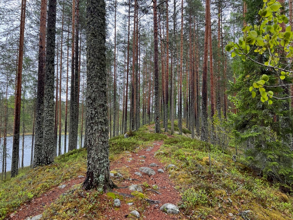
This day had the most beautiful scenery of the hike. The trail follows the ridge of an esker (Finnish: harju) flanked by lakes and wetland. It's fun to walk on, too.
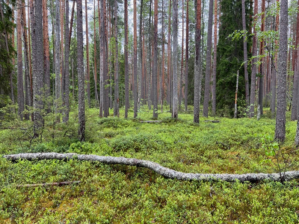
Then there was the old-growth forest of Petkeljärvi National Park. Compared to the usual commercial forests, it looks messy: the trees are of different ages and there are a lot of fallen trees on the ground.
Since it was May, both the Petraniemi camping area café and the Möhkö museum village were closed. Be sure to check the opening times if you're traveling off-season.
Once you leave Petkeljärvi National Park, you get to walk along the road. Consider hitchhiking to Möhkö — you won't miss anything.
My plan was to have lunch at Möhkö lean-to, but I never found it. According to the GPS track, I'd been within 10 meters of the right place, but I guess you don't see it when you approach from the village. I had lunch in my tent next to a forest road.
It rained the whole day, and it was making me miserable. Luckily the Pohjoinen Pitkäjärvi wilderness hut was cozy. There I met the only person I'd meet on the trail, a woman with her dog (hi Pinja, hi Ulla!). She had arrived early and warmed up the hut. It was good to be able to dry my clothes.
Day 3: I passed Kiieskangas lean-to and set up camp next to the trail a few kilometers later.
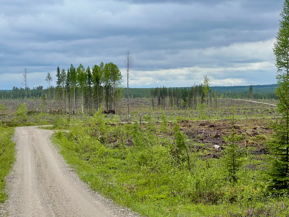
The scenery was a mix of forest paths and roads that go through commercial forests. The trail passes large clear-cut areas. I found it pretty boring.
There's a well at the Särkkäjärvi wilderness hut. There were no water quality results available, but I filled my water bottles and drank the water without filtering it.
Unlike the other lean-tos, Ölkönlampi is not designed for sleeping in. It has benches but no floor for setting up your sleeping mat.
My original goal was to reach Linnalampi. It would have been my longest hiking day ever. However, soon after Kiieskangas lean-to, my left foot started hurting. I texted a friend who had had similar problems, and she advised me to stop immediately and rest.
The forest path I was walking on was alright for camping, so I stopped and set up my tent. It turned out to be a good call, as it started to rain soon after.
Day 4: I walked to Ilomantsi and traveled back home. My foot was better in the morning but not great, so at Putkela I left the trail and walked back to town along the main road.
I would've loved to hike the whole route — on the map there's a nice-looking long esker from Putkela to Hiislampi!
At Ilomantsi S-market, they were selling ilomantsilainen vatruska. It's a potato dough pastry filled with rice. It was a nice surprise that I got to taste a local delicacy.
Gear notes
I've posted my gear list on LighterPack. My base weight was 8 kg. Here are a few highlights:
I like my PyraOmm Plus pyramid tarp, but only when I can use it without an inner tent. There were no mosquitoes yet, so it was perfect for this trip.
My Rab Cirrus Alpine insulated jacket saved the day once again. It's warm and fits over all my other jackets. Perfect for when I'm not moving! I just wish it weighed less than 531 grams.
This was the first time I used shell gloves with insulated mitts. I was afraid the mitts would get soaked, but that didn't happen — they were just a bit damp.
It was overly optimistic to bring a sun shirt, sunscreen, and sunglasses.
If you're going to take the train to Joensuu this summer, note that on weekends they replace some of the trains with buses due to track work. Search for Kouvola–Joensuu on this page. ↩
"Lampi" literally means pond, and according to the map there's a small lake near Ölkönlampi lean-to. It was far enough not to be directly visible from the lean-to. ↩