Islands & Peninsulas
Just at the beginning of my summer, I feel compelled to finally complete this letter about two trips made in the previous summer before they are supplanted in my mind by new travels.
I have always been attracted to strange geography: rocky outcroppings, remote places, topographical anomalies...
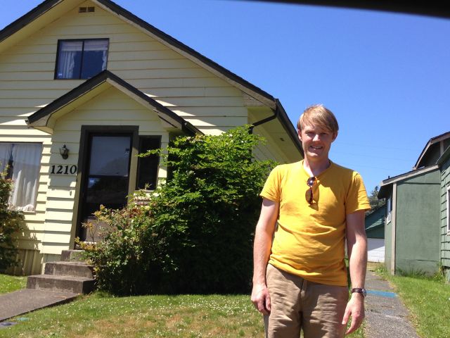
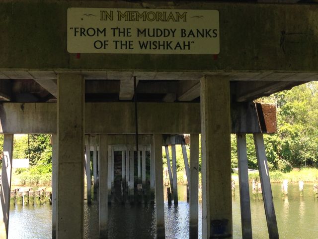
In July, while home in Washington State, I took a road trip to the Olympic Peninsula. For those who aren't familiar with it, the Olympic Peninsula is the far northwest corner of the continental United States--a strip of coastline split off from the rest of the state by Puget Sound, dominated by Olympic National Park. I hadn't been there since I was a Boy Scout and had tried to describe it to Oya on several occasions, but at each recollection I waded through such a variety of landscapes that it seemed they couldn't all belong to the same place. So I set out to put them in some kind of order. We drove south to Olympia and then headed west to Aberdeen, where I wanted to pay my respects to Kurt Cobain. Aberdeen is a depressed town, once the "Lumber Capital of the World," now an empty feeling downtown and a collection of poor neighborhoods. By mere coincidence Aberdeen has the biggest shop I have ever seen devoted to Star Wars paraphernalia. The owner of the shop gave us a photocopied map he had made of Nirvana-related sites around town. Our firsts stop was Kurt's house. It was one of many run-down houses in a run-down neighborhood. Within two minutes of pulling up in front of the house, three other cars stopped there as well. There was no plaque or any other indication that the city's most famous citizen had ever lived there. There is a small park on the Wishkah River with an engraved stone dedicated to Kurt and a sign with the lyrics to Nirvana's "Something in the Way" just a few feet from the bridge under which he ostensibly lived. It smelled like urine, and almost every surface was covered in graffiti. A man walking his dog said, "You're lucky, there's no needles today."
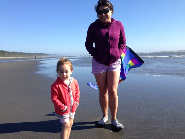
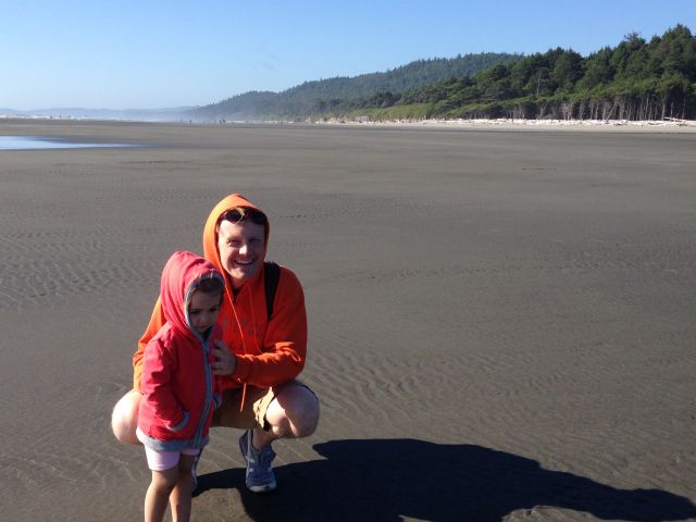
From Aberdeen we headed up U.S. 101 toward Kalaloch. Most of the route skirts Olympic National Forest, and it is a long time before you finally emerge on the coast. We had an unfortunate episode with a bumblebee that got into the car and stung both Julia and Oya in turn. When we arrived at our destination and saw the endless beach below the lodge where we stayed, we all felt a sense of relief. I know that I went to the beach at Kalaloch when I was about Julia's age but only had the foggiest memories of the Washington coast. It seems to go on forever in both directions, devoid of anything but massive pieces of driftwood, bleached white in the sun. We brought a kite for Julia and tried flying it on the beach with some success.
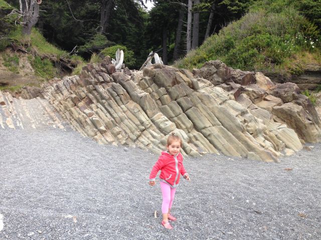
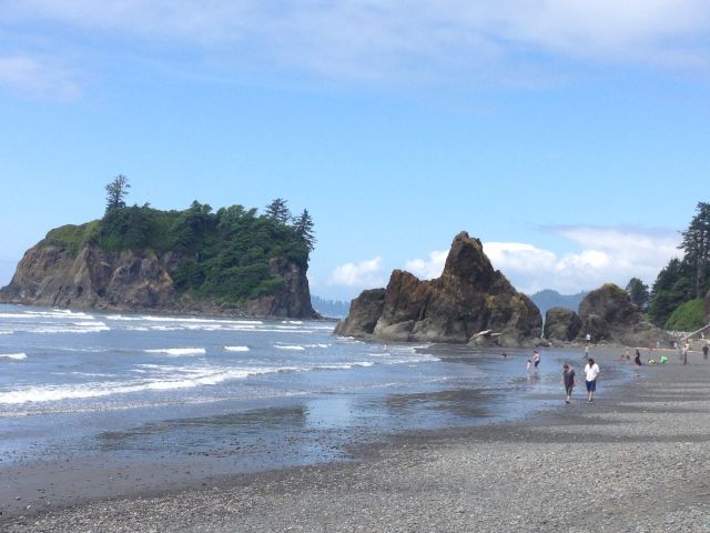
The Kalaloch Lodge, like the lodge at Mt. Rainier, has that rustic, old National Park-y feeling which I cannot quite describe. The building itself was built out of driftwood and sits on a bluff overlooking the beach. The color palette of Kalaloch is blue, off-white and grayish-brown in all directions, with touches of dark green where the forest meets the beach. It runs on and on for miles in a wonderful moody monotony. The following day we visited a very different beach to the north with sea stacks and tide pools accessed by a trail through the woods. At the Lodge, someone had mentioned a beached whale on one of the beaches a bit further north, and as we made our drive, my own morbid curiosity got the best of me, and I stopped at the trail head and went down on my own to see what I could see. After scrambling over about thirty feet of driftwood to the beach itself, I set off in search of this sight. What I found was a fouteen-foot gray whale (it must have been a calf) left far up on the beach by the tide. It was a reddish color, and bugs swarmed from its mouth. Its eyes, which seemed to squint, were black and dead. As I circled around to the other side, I got downwind of it and smelled one of th worst stenches I have ever smelled. I had never seen such a large dead animal before, and not bearing to look much longer, I hurried back up the beach to our car.
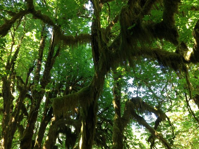
Our next stop was the Hoh Rainforest, which looks a bit like Dagobah in The Empire Strikes Back, with vine maples draped in Spanish dry moss. I had memories of a trip to Hoh when I was a kid and how I had expected Yoda to appear from behind a tree at any moment. This time, though, it seems to have been an unusually dry summer on the Olympic Peninsula, and the Hoh hardly seemed like a rainforest. From there we headed up U.S. 101, through desolate Forks and deserted Sappho, to Port Angeles.
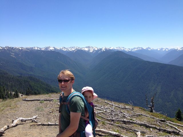
Other than a vague interest in Raymond Carver, the only reason for us to stay in Port Angeles was to go to Hurricane Ridge. This was another spot that I had remembered a failed outing to with my dad and Dan and David Fulton from our Boy Scout troop in which it seemed to snow sideways in the wind and everything was so white you couldn't make out anything in the landscape. Now it was summer and crawling with American sightseers s and Japanese hikers. We walked the trails above the visitor center in search of marmots and deer. There were wildflowers everywhere. The best thing about Hurricane Ridge is the way that everything around you seems to fall away into the unseen depths of valleys on all sides.
Heading east of the mountains, the Peninsula changes again as you enter the rain shadow in Sequim. The O. P., it struck me, is like Washington State in miniature, with all the differences you find in climate and landscape across the state, only packed into a small parcel of land. We passed the lavender fields and drove out to Dungeness Spit -- the longest sand spit in the U.S. One of my favorite Boy Scout outings had involved walking the five miles of the spit, which is only about 50 feet wide at points, with the water on both sides. Julia was asleep in her car seat at this point, and we were all tired, so we didn't attempt the hike but spent some time looking out over the narrow strip where it disappeared into the fog.
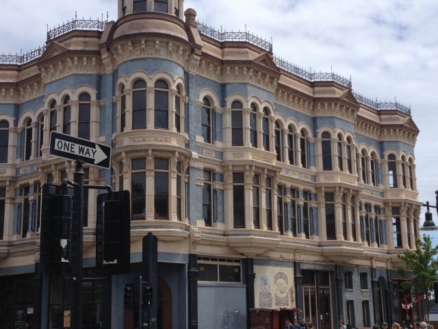
The final stop of our trip around the Olympic Peninsula was Port Townsend, situated up in the corner of the Quimper Peninsula, itself an extension of the O. P. Again, a town I had vague recollections of from a family trip as a kid. We stayed at the Manresa Castle -- a (supposedly haunted) hotel built in the late-1800s to look like a castle, up on a hill above the town. The degree to which Port Townsend seems prosperous in comparison to Port Angeles or to Aberdeen is striking. The old downtown is beautiful, a lot like Seattle's Pioneer Square. We spend a couple of hours poking around here and then out to Fort Worden State Park where we flew kites in a field among all the old wooden military houses. I even found Copper Canyon Press, who have published (among other things) some of my favorite books of Chinese poetry, but they were closed, so we had some oysters and cocktails next door.
After a second night at the Manresa Castle, where I expected ghosts but saw none, we headed south down a sun-dappled, tree-lined road, passing the resort at Port Ludlow where I also remember staying as a kid. And then we crossed the Hood Canal Bridge, on toward Kingston and the ferry back to the mainland.
**********
At the end of August, back in Turkey, we took a trip to to the Aegean coast along with Oya's father and stayed in Ayvalik for five days. This is one of those parts of Turkey that I figured must be interesting just because it looks so weird on the map. I likened it to an inkblot, with fingers that stretch out from the mainland into the sea toward Greece. Immediately off-shore, connected by a pair of bridges is Cunda Island which is itself more like two islands, connected by a narrow isthmus. We stayed in the old town of Ayvalik, which is all stone houses and cobblestone streets, most in disrepair. We stayed in a four-story house, where in the evenings from the attic windows I could watch flights of birds over the rooftops. The old town has one of the most distinct skylines I have seen in Turkey, spotted with broken brick chimneys that once belonged to olive oil factories, minarets, and a clock tower that sprouts out of a mosque. The Turks who came to live in Ayvalik and Cunda after the population exchange of 1923 were from Crete, and they brought their own Cretan cuisine with them. The mezes we had were notably different from the ones I've had in other parts of Turkey. The whole time I was there I had a feeling of not being able to place quite where I was.
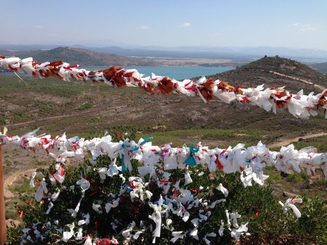
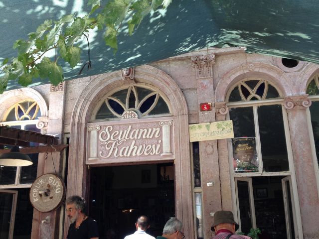
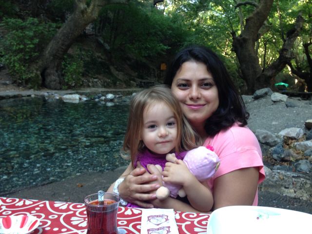
Outside the city, we went both north and south. To the south is Sarimsakli Plaj (Garlic Beach) and a hook of land the top of which is known as Seytan Sofrasi (the Devil's Table) which includes a deep impression in one of the rocks which is said to be the devil's footprint. This stone is enclosed within a cage, hung with red and white streamers. As I got close enough to snap a photo, I realized the rest of the people crowded around it were praying. Why on earth were they praying to the devil? Within the old town of Ayvalik there is a cafe called Seytanin Kahvesi (the Devil's Coffee), which we visited as well. It seems to be a local theme. To the north are the Kaz Daglari (Goose Mountains) -- Mount Ida of Greek mythology. We had two different breakfasts here: one beside a pool of fish and another in the leafy public square of a village. I took a dip in one of these mountain pools, full of snow-melt, which was the clearest, coldest water I think I've ever been in. Oya also took me to a seaside town she had lived in directly after high school just at the northern end of the Gulf of Edremit, but as with so many places in Turkey, she said it had grown beyond recognition.
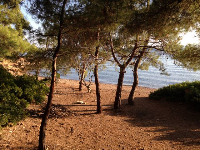
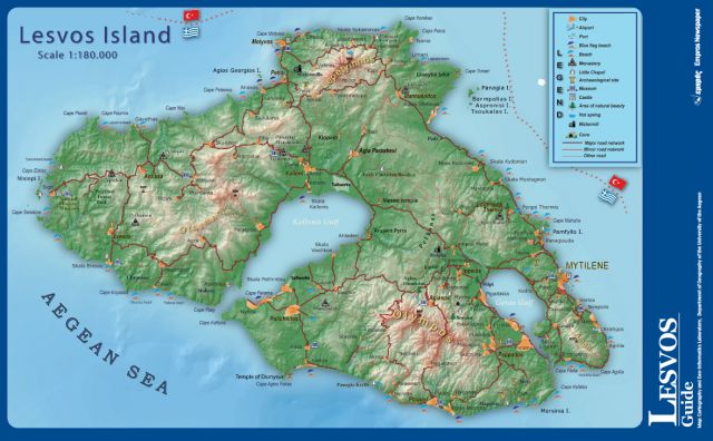
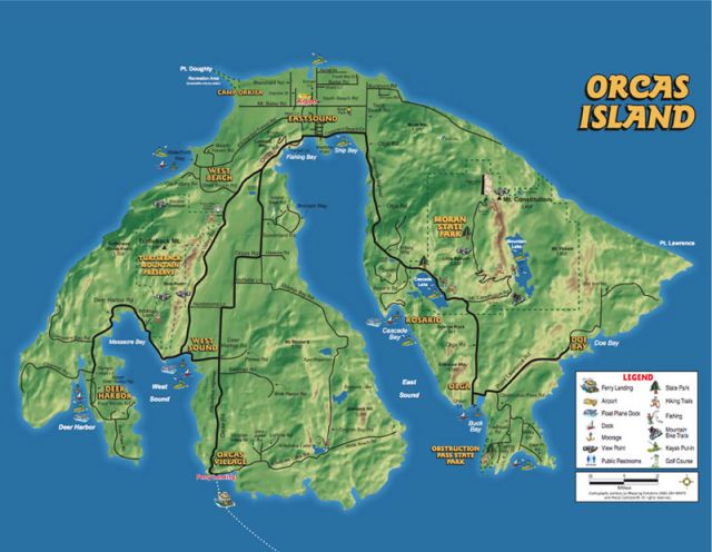
Three different times, we drove out to Cunda Island and walked through a grove of pines to a little swimming spot. There were several other people there, but there was no development and really no noise. We had a picnic each day and took a swim. The sea was cold, but the spot was unbeatable. Looking out across the water you could see the Greek isle of Lesbos. I had brought a book of Sappho's poems with me, and as I read them, I imagined that world she had inhabited, just across the water but then 2600 years distant. And maybe this is when I started to connect these two journeys in my mind. I thought about the shape of Lesbos and how much it resembled the shape of Orcas Island, just beyond the Olympic Peninsula, and about the little hamlet of Sappho, Washington that I had passed through. It seemed there was a continuity between these islands and peninsulas separated by 6000 miles.