Here in Stockholm, an element of the city that has surprised me is how much of the built environment—bike paths, big regal buildings, transit, shops and restaurants—is built right at the water level. As I have walked around, the water has been as little as 20 cm below the pavement I'm standing on, across both the "lake" side (west) and "sea" side (east), per Gnamma #94. Given that I think about flooding and sea level rise a lot in my professional work, my immediate response to this has been "holy shit! is anyone worried about this?"
 Tunnelbana station right at lake level in Stockholm. Photo from here.
Thankfully, the answer is yes, the city does think about it, and Stockholm actually doesn't have immediate high risk: the lake level is kept steady by managing flow through the sluices/locks, and the region is undergoing uplift keeping up with sea level rise (i.e. the relative sea level rise is very small), at least for now for now. The city is also investing in some semi-long-term (until 2100) infrastructure plans to help manage.
Part of my surprise with this always-near water level is also because I've gotten accustomed to living in a place with medium-sized tides: San Francisco has tides that can be bigger than 2 meters, representing daily changes in water levels taller than I am, and a built environment that reflects these variations. In places with tides, everything needs to be built above the highest tides, at peril of frequent flooding.
But the Baltic Sea has virtually no tides! The water level is essentially static! I want to write about how this works, and more generally, what the hell are tides?
 Comic from XKCD, because tides really are bizarre.
At the scale of the solar system, the earth is a big squishy ball covered in a layer of water, rapidly orbiting around the sun in a not-exactly-circular orbit while also spinning on its axis. It also has, much closer than the sun, the moon which orbits around every 24 hours and 50 minutes in also a not-quite-perfect circle. The moon and the sun—in that order—tug on earth, and the water on earth, via gravity. This causes the water on earth to slosh around, as the water gets pulled towards the moon and sun. Together, there is a long list of astronomic cyclical effects and combinations of cyclical effects which are called tidal constituents. These cycles include the moon's orbit of earth, lunar months, the earth's orbit around the sun, the ellipticality in the moon's orbit, etc—there are hundreds. They all have abbreviated names, like M2 for the diurnal moon and S2 for the diurnal sun. (They get weirder: MN4 for "shallow water quarter diurnal." But these matter much less in the grand scheme.)
 Animated figure showing M2 components moving around the globe. From the widely-adopted tide model by Oregon State University, TPXO.
All of these constituent cycles add up and then collide with the actual geometry of ocean and earth on our dear planet Earth. This leads to a lot of tidal variation across the globe. Some places in the world have semidiurnal tides (half-twice daily): two high tides, two low tides a day, often of different heights). Some places have diurnal tides: just one high and one low each day. Some places have no tides. And the magnitudes of the tides vary on weekly and centuries-long timescales due to how all of these forces weave together and their natural oscillations (like, the moon getting closer and further away from earth or in-and-out of alignment with the sun). You may have heard the term "king tide" which just denotes a particularly high tide: this usually means a few of the tidal constituents are all aligned for a day or two, piling on top of each other to lead to high water levels.
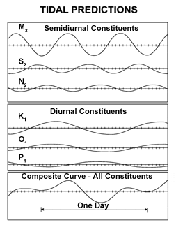
Diagram of how different cyclical tidal constituents add up into one wacky water level variation. (from wikipedia).
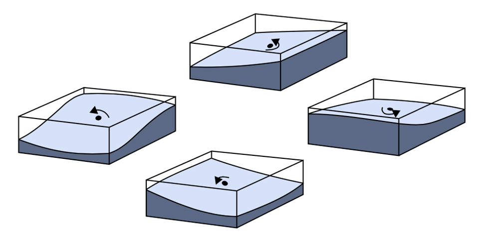
Water sloshing around a fixed "amphidromic" point. (pic from here)
Regardless of all the different manifestations of the tides, where there are changes in water level, the motions tend to slosh around in circles, the way you might imagine it in a kiddy pool being rhythmically shaken. In the middle of these sloshing circles ("amphidromic systems") are fixed points ("amphidromic points"). There are different tidal circles/amphidromic systems across the basins in the world. Here's a nice old graphic indicating the tidal magnitudes (blue contours), amphidromic points (red dots), and phase lines (red contours, where the tides "progress" from 1 to 12 in counter-clockwise circles) in the North Sea between Great Britain and Europe:
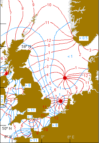
Tidal patterns in the North Sea (M2). From an old archived page here, found via stackexchange.
The locations of amphidromic points—the points with zero tides—are the results of the cycles tugging at the water and the particular geometry of the land and sea. Tides are generally bigger further away from amphidromic points within the same basin, but can be dampened or forced by local geography. Because the Baltic Sea is a relatively small basin of water (relative the big oceans!) and the straights of Denmark, which connect the Baltic Sea to the North Sea, are very shallow, this prevents big tidal swings in the Baltic. There are some tides, up to 30 cm or so, but mostly on the east coast near Finland, Estonia, and Latvia. Some of the big lakes in the world have very very tiny tides, too, but these typically get drowned out by other stuff like waves and air pressure effects.
Whew! It's complicated! Some of the magic of tides—to me, at least—is that how they show up is hyper location-specific. The unique aspects of a coastline can dampen individual constituents while enhancing others, in the same way that a tuning fork resonates with some frequencies but not with others. When people need to make tidal predictions (to help predict currents, or for port operations, or coastal management), we need to make locally-based observations in order to understand how the tidal constituents manifest in a specific location. And sometimes they combine in nonlinear ways that are difficult to understand without long-term observations or really well-built models. Especially in shallow waters, where friction plays a big role, constituents can to form large variations in water level and timing of the tides, called "overtides." In my short-lived position at Cal Poly SLO, I worked with a professor who has contributed a lot to this space, unearthing old hand-written records of water levels, cleaning and digitizing them, and synthesizing them with modern-day observations to help build out better tidal understandings, especially in the "new world" of North America. The tides respond as cliffs erode, rivers move around, and we humans dredge harbors or otherwise modify our shorelines. While the astronomic forces aren't changing (quickly, at least), he wrote a great paper on how the tides are changing in response to many other effects.
I've found it difficult to get a firm grasp on tidal dynamics at a large scale: there's actually a lot of misinformation out there, and because the dynamics can be so localized it's tough to get a big general idea of their global cycles. The two best resources for me have been NOAA's Tidal Analysis and Prediction guide and Understanding Tides book.
So what are tides? Big sloshes of water, going in circles around the basins of the world, because of the dance between the earth, moon, and sun, resulting in water levels rising and falling cyclically. I'll get to an elevator pitch-length version someday.
Elliptically,
Lukas
P.S. The water is not the only thing on earth that deforms in response to the moon-sun-earth gravity dance. So does the earth itself, as a (geologically) squishy ball! This is called an Earth Tide.
You just read issue #96 of Gnamma. You can also browse the full archives of this newsletter.