Bonjour, Namaste, Aloha
New support for overseas forecasts, and adding all 50 states (in more ways than one)
Happy spring, fellow fliers. This newsletter announces a major new feature for BumpySkies, my free turbulence forecaster, so let's get right to it.
BumpySkies supports international forecasts
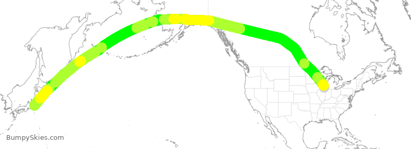
BumpySkies now provides full turbulence forecasts for international flights that either depart from or arrive at the United States. I'm still tweaking the details of how the site displays these often extra-long forecasts—it hasn't had to show a flight longer than six hours, before this—but I'm really happy with how it works so far.
BumpySkies has sorta-kinda supported international forecasts for quite a while, insofar as it would try to display a such a flight's forecast map if you requested one. But the map was still entirely focused on the contiguous US, and the flight-path line simply stopped at whichever edge of the map the overseas flight crossed. No longer: the map now shows the whole section of the world that the plane plans to fly over, and the forecast line extends all the way from origin to destination, with full turbulence-forecast coloring added.
This new feature is made possible from two data sources that BumpySkies added this year. First, the new FAA flight-plan source that I wrote about in January supplies international flight routes as well as domestic ones. More importantly, the BumpySkies project has been granted access to the numerical data that powers the World Area Forecast System (WAFS), another product of NOAA's Avation Weather Center, the US government-funded organization that publishes the weather data BumpySkies has used for the last decade. But that data source only covers the contiguous US; WAFS contains weather data for the whole planet.
I extend my gratitude to the folks in charge of access to WAFS data, which is open only to air-travel operators, or to projects directly relating to aircraft navigation and safety. BumpySkies's purpose is admittedly tangential to this mission, but I made its case just the same, describing it as a service that improves international air travel by easing the anxieties of nervous passengers, nearly 10,000 of whom visit the site every month. After some dialogue with the WAFS data-access team, BumpySkies was granted its API key—and now you can see the full turbulence forecast for a flight from Chicago to Tokyo, as illustrated at the top of this newsletter.
My thanks also goes out to the Natural Earth project, whose free geographical data underpins the new world map that BumpySkies uses. It felt a little bittersweet to retire the map of the contiguous US that I hand-drew when I first launched BumpySkies ten years ago, but I'm happy that was able to more or less replicate its minimalist attitude using the Natural Earth data.
This is a free newsletter, by the way
You've read half of this issue of BumpySkies News! Perhaps you'd like to subscribe for free?
Forty-nine and fifty
As a side effect of supporting overseas forecasts, I am happy to report that airports in Alaska and Hawaii finally get their due representation in BumpySkies. I was always a little sheepish about how the website treated these two states as if they were exotic foreign lands, located literally off the map. Now it simply treats them as more of America, as it always ought to have. You can even get forecasts for Hawaii's half-hour inter-island hops, if you'd like!
And the other forty-eight, too
Speaking of states, the BumpySkies forecast map now shows the outlines of all 48 contiguous ones—as well as the Great Lakes—again thanks to data available through Natural Earth.
This was a feature suggested by a flier during last winter's user survey. It took me a while to come around to the idea, because I did like the site's original, super-minimal map that showed only the outline of the whole contiguous US. But then I took a few more flights myself, and was reminded that when I use the seat-back map on domestic flights to track the plane's progress and position, state borders provide natural markers and milestones.
In became obvious, in retrospect, that state borders can help BumpySkies users have a better notion of where to expect bumpier patches. So, when I had to redo the site's maps for the sake of international support, I threw in state borders too. For the sake of simplicity, I kept this only to American states; if you'd like to see the borders of other countries or provinces marked off as well, drop me a line.
A new airline picker
Lastly, supporting international origins and destinations means supporting a lot of new airlines, especially ones based outside of the United States. And this meant saying goodbye to the old airline-picking interface, which for many years was just a simple menu. It grew a little bit last year with the addition of Canadian and Mexican airlines, and I had fun organizing it into little categories, marked with appropriate national-flag emoji. However, pouring in every single airline that lands in the US would have made that menu much too long to use comfortably, especially from a phone.
So, I took inspiration from FlightAware's lovely single-field search interface, and replaced that menu with a "combo box" that lets you type in an airline's name or code—UA or UAL for United, for example—with a list of clickable auto-complete suggestions appearing as you type. It's a little different, but I feel hopeful that it works quite well to let you enter a wide range of airlines—what do you think?
As with replacing the simple, static map that BumpySkies used before this week, it does feel a little sad to change a feature that worked so well for so long in utterly JavaScript-free simplicity. I suppose I can be glad that BumpySkies is now old enough that I can start to feel a little nostalgic about elements I've had to retire in dignity, so that newer features can shine through.
And that's all for this issue! I'm really excited about everything I've been able to bring to BumpySkies since the year began, and I have you all to thank for your guidance and support. Bigger things are still ahead for the site—but until then, I'd love to know what you think of the new features.
Wishing you happy travels and smooth flights this spring,
jmac